Mostly, this is random stories from my various trips as I collect them, but I've a wee backlog to get through too and those will pop up occasionally.

Feel free to leave comments.

Friday 24 October 2014

Looking for Wade again

Anyone who has spoken to me about my wanderings round Scotland, or has read this blog for a while, will know of my fascination with old routes. There's something about the history of them and the decisions that were involved in their creation and direction that catches my imagination. Amongst the most evocative are the old "military" roads mostly ascribed to General George Wade, but often created by his successor, William Caulfield. Many of these old roads still follow the most "logical" way of traversing the countryside and so remain an excellent resource for those of us on foot or cycling and who wish to avoid the modern highways. 

I've recently been looking for  a good off-road route from the Cairngorms into Inverness and it was inevitable that the old Wade road would come into my sights. I'd also been asked by Scotways to report back on the current condition of the road north of Moy so I had an ideal incentive to undertake a bit of surveying. 

I've previously written about the section of road from Aviemore to Tomatin here. In essence, it all works really well as a walking or cycle route until the downhill section into Tomatin. Here, the old road is completely overgrown and moss-filled requiring a short detour over the adjoining fields.

From Tomatin, the old road has been almost completely overlaid by the railway and the various alignments of the A9 until the small village of Moy is reached. From here, the start of the route is handily signposted and goes to Lynebeg and Lynemore via a crossing of the A9. 


Local news beside the Right of Way signs

There is an official crossing point, but take great care
After a short distance on a good track, the Wade road can be seen heading off to the right. It's little more than a depression in the ground in some places and where there is an embankment on both sides the inability of water to drain away has resulted in some significant standing bogs - mostly quite shallow though. 
 
Take the right-hand track at Lynemore (NH762339)


The line of the road is obvious (even when waterlogged) and can be seen on the hill beyond

When the forest becomes more visible the gate ahead allows access into a narrow clearing. Just before this meets another good forest road, it's necessary to cross a wee burn. There are no obvious signs of a bridge here so there's a chance that the burn has swollen beyond its previous flow as a result of the surrounding forest. 


The gate is fairly obvious as is the clearing behind

No sign of an ancient bridge here where the clearing ends and joins the new track (NH748343)
The new track now hides the original surface from use but it's a good route, high enough up the hillside to give some airy, open views. 

Staying right parallels the modern A9

A cairn to mark the Rout of Moy (at NH 730347)

Around midnight on 16th/17th February 1746, Lord Loudon, the Commander of the Hanoverian forces in the north, mustered 1500 troops from the Inverness Garrison and set off on the twelve mile march south along General Wade’s Road to Moy in a bid to capture Prince Charles Edward Stuart. The prince, a guest of Lady Anne Mackintosh (Colonel Anne) at Moy Hall, had arrived with a small guard of 50 men, some distance ahead of his retreating Highland Army.

Pitch darkness interspersed with flashing lightning slowed and unsettled the marching men.

Watching the road here, 3 miles from Moy Hall, was an ‘outer guard’ of just five Jacobites led by Donald Fraser, the Moy Blacksmith. He had chosen a spot where he could observe movement on the skyline to the north in darkness, and where he had cover to the south in daylight. Nearby to the east, peat stacks remained out on the moor. Here he planned to harass, and perhaps deceive, the enemy.

As the Hanoverian Column, spearheaded by the Laird of MacLeod and his men approached in the darkness, they were surprised by sudden musket fire and loud war cries urging clansmen to battle. Even the peat stacks threatened in the flashing lightning. Convinced that the whole Highland Army was at hand, Loudon’s men turned in panic and fled back to Inverness, somehow carrying off the body of Donald Ban MacCrimmon, Piper to MacLead and the only fatality of the night. A premonition of his imminent death had been realised.

As the road goes downhill again it has to veer off the Wade route due firstly to the A9 and then due to some quarry workings. For the real Wadeophiles it is, however, worth making a short detour along the original route to see the old bridge over the Midlairgs Burn. 


Wade Road on the left, modern forest track to the right (NH721359)

Lovely old bridge over the Midlairgs Burn (NH716361)

Go much past this and you'll come up against the quarry gates with their rather prominent warnings of imminent death! 


Continuing on the re-aligned road it's not long before the farmhouse at Auchbain is passed then we pick up the Wade route outside the front entrance to the quarry. 


Pretty clear

Original alignment straight on, revision to the left. There's a RoW sign hidden in this photo.....

There's a short section of tarmac, before a right turn onto the B851 road to Farr and then an immediate left to the bridge at Faillie. This is a typical, steep bridge and the road surface at the summit is well marked by the passage of low vehicles. 


Faillie Bridge. Not recommended for sports cars

From here, the route gets a little difficult to find, mostly because of the recent housing developments. Eventually, I spotted a sign hidden in the bushes where the current road seems to have been widened to accommodate a lorry turning. The problem now is that there is a huge embankment to climb up - difficult enough on foot and more so dragging a bike. 


That's the RoW going up the embankment on the left. I actually repositioned the sign after this photo.

This re-aligned section carries on to the back of a modern house then joins the original route uphill through a very overgrown section between a field and a fence. It's not hard to see why this has been left to the undergrowth as the gate at the top has been locked (not sure this is legal if it's a Right of Way), thereby restricting passage. 


It was just about possible to find the track through this vegetation. The locked gate doesn't help.

With the proliferation of shrubs and long grass, combined with the steep angle, this became a bit of a push rather than a ride. Beyond this gate the track is visible as a field boundary, carrying on in a straight line to the minor road through another gate (unlocked this time).

Crossing this road there's an obvious, signed march through the woods with dykes (mostly well overgrown now) lining the route. 


Entering Dundavie and Daviot Woods
The alignment is obvious the whole way as it's almost arrow straight and continues through Dundavie and Daviot Woods on a mostly good surface until the crest of the hill is reached and there's a change in the air as you start descending to the outskirts of Inverness. 


The outskirts of Inverness and the view North


And looking South
From the top of this restricted access lane, it's a fast descent down to "civilization" and the big city. 

At the junction of the Old Edinburgh Road and Stevenson Street
All in all, I'm pretty happy with the route. If anything, I think it works better going South where the one possible pushing section north of Faillie is therefore rideable. I can imagine that the last section of singletrack into Moy itself could be horrendously boggy at certain times of year but it's all typical Scottish mountainbiking. This links up pretty well with the section from Tomatin to Aviemore, providing an almost exclusively off-road route all the way to the Cairngorms and beyond to Kingussie and Newtonmore. 

As for my day out, I really enjoyed tracking down the old road. In places, the original alignment has been bypassed altogether and is sometimes easily missed (in fact I think I've subsequently spotted an "orphaned" section on the east side of the A9 south of Auchbain). A combination of map reading, aerial photography, on the ground assessment and, sometimes, downright wishful thinking, seems to bring the route alive and it's not too hard to imagine yourself in George Wades head, seeing the land as he saw it and trying to decide where his road should go. In places, it has survived remarkably well. In others, centuries of non-use have made it almost impenetrable. Either way, it still stands as a remarkable achievement. 

Other details and descriptions of this route can also be found on the Scotways Heritage Paths website, here

Thursday 2 October 2014

New toys!!

I'm getting a bit more fussy in my old age. Whereas I'd once wander the aisles of Tisos or Nevisport, eyes agog at the wonders contained within, I rarely visit such emporia these days. I'm sure there are still lots of wonderful new things to be discovered but I just hate the whole experience and I seldom see anything that exactly matches what I'd spend my money on. I put it down to developing more preferences, knowing from experience what works - and what doesn't - and not wanting to compromise. 

This change has been accompanied by an explosion in availability of some very well-designed kit from many small manufacturers, made available through the wonder of internet shopping. Of course, it's always a risk shopping like this. You can't inspect the quality of the goods and things like fit, comfort and "feel" are only possible to check once the goods are available in the flesh. However, it's often worth the risk of a poor purchase to get something that's just what you were looking for. 

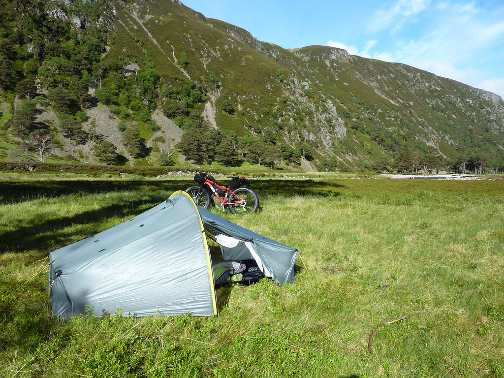
A couple of years ago, I bought myself a new (actually, secondhand) tent. It's a Scarp 1 and has been great for some all-season camping. It's pretty lightweight compared to some of the tents I've used before. It's a bit fussy when pitching and needs a decent flat area to get it just right but it's pretty bomb-proof and very cosy in colder weather.

Scarp 1 in Glen Etive

P1040204
A good pitch in Glen Feshie

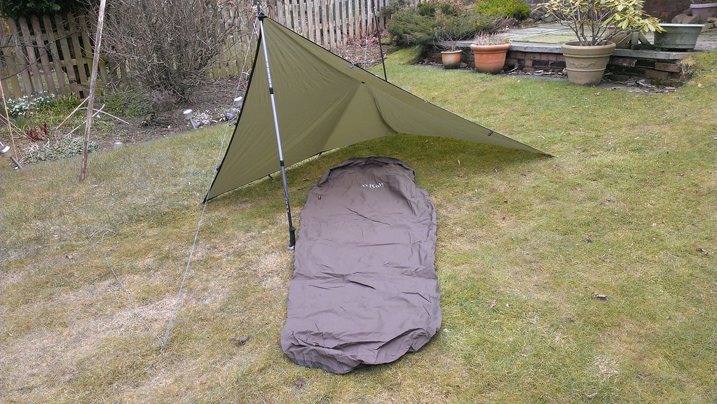
I then decided to try out bivvying. This has worked better than I'd hope. The flexibility of not having to peg anything out makes short overnight stops very easy. Couple that with a small tarp and you get a bit more shelter and somewhere under cover for cooking etc. It's still a bit cramped though and I reckon I prefer a bit more shelter from the elements when the weather isn't too great. 


Untitled
Experimenting in the garden. This "flying V" is my favourite tarp layout
Bivvy bag and tarp above Kinlochleven. Bike being used as a support.

So - I got to thinking about what would be a great combination of the two systems. I imagined a tarp that was a bit bigger, with a pole to give some height. It would have a midge-net built underneath it, linked to a suspended bathtub groundsheet for bug-free sleeping. Ideally, the door would be longitudinal, giving a decent sized porch for gear storage and cooking. It would need to have great ventilation to avoid the build-up of condensation we so often suffer from in our climate and it would, of course, be ultralight. 

Luckily, someone pointed at the Six Moon Designs website and the Lunar Solo tent. Here, it seemed was my design made real.  After my usual bout of swithering, several months later I ordered it from backpackinglight.co.uk and today it arrived.


I've obviously not had a chance to try it out yet. The seams will need to be sealed and I'll want to experiment setting it up a few times to see if there are any snags. However, it seems to match my list of requirements pretty much 100%. I bought a very lightweight carbon pole to go with it but a normal walking pole can be used instead if I'm hiking. It's certainly very lightweight. At just over 700g (including pole and pegs), that's less than my tarp and bivvy bag combined. Internal space is very good - especially as I'm only 5'7" - and there's enough room to get some bags inside with me as well as more space under the porch. The only issue with the latter is that it's quite high off the ground so anything underneath it couldn't be guaranteed to stay dry. It'll also need careful pitching to ensure that any wind is coming over from the rear. 

I reckon there are a few more nights of suitable weather this year before I might need the extra shelter of the Scarp and I'm really looking forward to trying it out.

Wednesday 24 September 2014

Ch..Ch..Ch...Changes

Since starting my new job at Ticket to Ride in Inverness I've seen quite a few tourists come in and head off on of our hire bikes to do a wee tour. It got me to thinking that I've been very much concentrating on the mountain biking during 2014 and not any road riding. With the end of August fast approaching and the need to head off for another night under the stars I decided it was time to ring the changes and do something about that.  

Another reason for wanting to get out and about was that I'd just built a new set of wheels to be used on both the touring bike and the 29er. The front wheel incorporates a dynamo hub. Teamed up with a good LED light from Exposure this would finally eradicate all that unnecessary stress I give myself whilst riding in the dark and worrying about how long my batteries will last. 

The chosen route was simple enough. I'd always fancied a circumnavigation of the Cairngorms and an overnighter would make it a fairly easy-going pace. Fortune smiled on me as the weather forecast for the only two days I had available turned out to be excellent so I could go lightweight too. 


In a previous post, I outlined my bikepacking gear list. That included a tent and a winter-weight sleeping bag. Ditching the former for a bivvy bag and the latter for a lighter, less warm bag, along with a couple of other tweaks reduced my load quite a bit and it easily fitted into the Viscacha seat pack and a dry-bag mounted into a Revelate Harness on the handlebars. 


Compact handlebar luggage
Heading off south from home I was immediately aware of the headwind. Still, I wasn't in a hurry and planned to take things easy so I was unlikely to be running late. As it was, I soon reached Dalwhinnie (noticing that there's now a cafe in the old hotel building) and then on to the run along to Drumochter. I was just going through the gate onto the cycle path at the summit of the pass that I met this lady cycling north. As it turned out, she'd set off from Kirkmichael that day and that was, roughly, my destination. We had a wee chat about possible eating places and then I noticed the electric hub and battery on her bike. After a wee jibe from me about that being "cheating" she assured me it wasn't as it only cut in whilst she was going uphill :-)

The descent to Blair Atholl was lovely. It's a great ride along the old road into Struan and then a short spin to the Watermill cafe in Blair itself. Although clouding over a bit since Aviemore, it was still very warm when the sun came out, though cold when it was blocked. In fact, there were times when one layer of clothing felt too much and others when three seemed barely sufficient. My initial target of getting to Pitlochry before 6 pm seemed pessimistic now and I was soon through it and heading up my first real climb of the day to Moulin. This went in fairly quickly and the undulating road to Kirkmichael was both quiet and scenic so time passed fairly speedily too. As it was, I found myself at Kirkmichael just before 6., well ahead of schedule and earlier than I'd planned to eat. However, I was aware that there would be no other option between here and Braemar and with the Cairnwell climb ahead of me I reckoned it was better to eat now. 

One of the pleasures of solo touring is the chance to chat to folk en route and so it was I got into conversation with the barmaid and then the manager of the pub. Not about anything in particular, just that easy-going chatter about the seasons and how busy or quiet things are. Suitably replete, I did a few stretches and set off into the slightly cooler evening to see how far I was going to get before bivvying down. 


Low sun giving the hills of Glen Shee red tones
The road is gentle enough (though longer than I'd remembered)  until the Spittal of Glenshee hotel is reached. This might have made a good eating/camping spot had it not burnt down only a few days previously (though it was already closed at that time). From here, the road turns north and the climb to Cairnwell makes itself felt. As my rate of progress lessened, so did the daylight. By the time I'd reached the building of the ski centre, the dynamo headlight was in full use and it was around 8:30. Now I had a choice. I knew it would be a fast run downhill to Braemar, a pub and a sheltered river-side bivvy spot. However, I could also tell that it was going to be a very cold night at the bottom of the valleys so I opted to stay high, just where I was. I managed to find a suitably sheltered doorway to lay out my sleeping gear - one that also mostly killed the constant drone of a nearby generator too. As the few passing cars became even fewer, soon the only remaining sound was that of the local grouse population. 

It's certainly one of the strangest places I've slept and once again proved the advantage of taking bivvy bag rather that tent. 


My wee corner was tucked away enough that the first light of day had been and gone by the time I awoke but I was still early enough to watch the sun gradually rise over the hills and take the chill off the morning. 


Not your usual bivvy bag view
After a quick porridge I scooted down to Braemar and wasn't surprised to see that my forecast of low-lying dampness had been correct. 


Brrr - chilly!
I was still feeling a bit hungry so popped into the Fife Arms to see if they'd do breakfast for non-residents. After a bit of confusion, it was confirmed this was OK and I stocked up my internal stores for the forthcoming ride. 


First summit of the day - and certainly not the last

The road fairly undulates across some pretty high and remote terrain and it was all looking splendid until I reached Cock Bridge. Here, the road seems to rise almost vertically away from the river so I grabbed the lowest gear possible and started spinning then forcing my way up. 
It doesn't look steep now!
The first steep climb actually went in OK, as did the first couple of bends and then I could see a slight decrease in the angle. Unfortunately, this proved to be a bit of a false dawn and the steepness of the tight left-hander had me barely crawling, with a couple of cars behind me. At this point, I decided to step off the bike and ended up pushing a few metres onto the next straight before getting back on the bike to continue.

The road continues to rise some fair way before the ski apparatus of The Lecht becomes apparent. 


The last big climb
I was certainly glad to pull in again and pleased to see that the cafe was open so that I could refuel. Of course, what goes up must come down, so it was then a full-on dash downhill towards Tomintoul. Once here, it felt almost like being home and I was happy to spin along in the warm sunshine to get back home and complete the loop.

Still time for an ice cream on the way home


Almost home
I'd certainly enjoyed being out on the road again. I guess I'd almost forgotten how nice it is to spin along making a decent rate of progress and enjoy that there's almost always a choice of places to stop, eat or just chill out a while. The new lighting system promises to make more winter riding possible so I'll be looking at possible routes.

Another thing that did go through my head was the fact that I always tour alone these days (poor Paul and David - I think I wore them out). Maybe I need to find a touring buddy for 2015.

Tuesday 5 August 2014

Summertime.... and the living is easy

Summer. Long days, warmer weather, drier ground. Little wonder thoughts turn to epic days out. Those long ridges, the summits, the sound of tyres skipping over dry, rocky trails. The unfashionable warm spell has got me to thinking a wee bit about how I've been spending my time out of doors and I've decided to slow it down a little. Warmer weather also means it's nicer to relax, to watch nature in full flow, to dip your feet in the river and just enjoy what's all around you without needing to be in a rush to go anywhere. Sort of reminds me of an old TV ad....


With that in mind, I've spent some time on easier walks or simply mooching around some fantastic spots in Scotland. Mim and I had a few days in Blair Atholl, including a walk up Glen Tilt. With summer flowers around and a lovely river to cool down in it was just about perfect.

So - not so many words this time, a few more pictures.....


First view up Glen Tilt
Looking further up Glen Tilt
Cooling off in and by the river
Summer is also about cream teas!

The second week of our holiday was spent in the Western Isles. Though I've been through the Outer Hebrides before, Mim never has so we spent some time on North Uist doing some sightseeing, a couple of walks and some paddling in the new kayak.


Horgabost beach. Does it get any better than this?
Lovely quiet campsite at Balranald
Machair
More Machair
Two Oyster Catchers - I love their call
Great sunset right beside the campsite
In the new kayak, exploring the coastline

I'd also long had a hankering to do a specific little walk, following the route set out in a Runrig song - Flower of the West.


I look over Orinsay
To the Trumisgarry shore
To Aloter
And the road to Ahmore

Past Loch Scadavagh and Loch Fada
And the Flatland to the East
Where the dark blue mass of Eval
Meets the rising rock of Lee
Between the Crogary and Maari
I started to descend
Loch Aongais on my left hand side
I look across to Clett
Collies barking on the outrun
Dunlin dancing on the sand
Breakers show round Corran Vallaquie
And empty the Atlantic on the strand


We headed up Crogary Mor on a mostly clear night and took in the sun setting over Corran Vallique before heading down with "Loch Aongais on our left". 


I even got to do my July bivvy-a month,, "escaping" from the campsite one night and heading for a long spit of land on North Uist. My initial plan had been to bivvy down at the trig point on the wee headland but it was thick with flies and I had to find a spot surrounded by sand to finally get away from them. It was a lovely location, with views out over the sea to Harris, but I was strafed by two large owls for 30 minutes or so. I don't know if it was me they were interested in or if there were lots of flying insects in my vicinity but it was fascinating and a bit uncomfortable to have them swooping so close to me.  After a good nights sleep, I was rewarded by a fantastic sunrise.
About as dark as it gets
Sunrise over Harris
Yes, we even have "C" roads here
On my previous visit to North Uist, Paul and I had almost sprinted through on our way to catch the ferry to Harris. This time, in an almost perfect summer week, I'd finally taken the time to explore and experience it. 

Wednesday 25 June 2014

Twa Lairigs

Sometimes you just get that urge to do something that everyone says you shouldn't. I guess it's a wee lost remnant of the naughty boy who won't do as he's told. In my case I'd been looking at maps of the local area of the Cairngorms and I kept spotting this obvious way through the hills. To make things worse, I look at this obvious route every time I look out my bedroom window. Regardless of the season, the Lairig Ghru shows as as a deep defile through the plateau, inviting me to explore it. So it was that I decided to incorporate it on a wee route into some unfamiliar spots and to tick off my June bivvy-a-month at the same time. 
Ready to set off - the target behind me
The weather wasn't looking too promising as I headed off towards Glenmore from home. It was warm enough, but a wee bit damp. However, in an effort to stay lightweight, I'd opted for bivvy bag instead of tent and to minimise the amount of extra clothing I'd be taking along. 

The road less travelled (by me, anyway)
After passing An Lochan Uaine (the green lochan) I took the right-hand path signposted for Braemar, pedalled up and down a nice bit of track, then came an immediate cropper. As my front wheel embedded itself in some hub-deep mud, I tried to unclip, got cramp in my thigh, and promptly fell over into a shallow puddle. I was stuck while the cramp released itself, unable to move from my position or get the bike off me. Luckily, my blushes were spared as it was only after righting myself that a hiker came strolling past.

I got going again okay, but my calf was now feeling incredibly tight and that was the last thing I needed for the push up onto the shoulder of Bynack Mor. Leaving the Munro-baggers path I was now on tracks I'd never explored before. There is a fair mix of walking and riding depending upon the terrain but I managed to make fairly decent time towards the Fords of Avon and the nearby refuge. 


Looking over to Ben Avon

Fords of Avon refuge
 It's a terrific wee place. Barely tall enough for me to stand up in and just about large enough to accommodate half a dozen prone sleepers, I can see that it would be a great haven in the event of the sort of adverse weather that could be expected along here.


The river crossing itself was OK. I opted to remove shoes and socks and cross barefoot in an effort to keep dry shoes as long as possible and the water never got above knee deep, though it was flowing fairly fast. 
The river crossing. 
The next section had much more walking than I'd suffered so far but I was glad to get to the col of the Lairig an Laoigh and start the fun descent into Glen Derry. This is surely one of the Cairngorms most beautiful spots, the wide flat valley interspersed with patches of woodland and the river carving a way through it. 


Dropping in to Glen Derry


Lovely singletrack along here
I knew I was approaching Derry Lodge when I started to encounter groups of tents, mostly with folk preparing or eating food. It served as a wee reminder that I hadn't been eating much and I wolfed down a couple of chicken wraps as I pondered on where I might stop for the evening.
Should I stay or should I go?
The flats here were certainly a possibility, though it was a bit more crowded than I prefer. However as it was still "only" 8pm, I decided to crack on a bit further and see if I could get anywhere near the Pools of Dee and the summit of the Lairig Ghru before dark. I'm finding that's one of the differences between camping and bivvying. With the former, I'm likely to stop when I see a decent pitch, settle in, cook up some food and relax for the rest of the evening. Bivvying is more about the short stop, finding a wee bit of shelter somewhere and making do in order to get going again quickly. 
Looking back along Glen Luibeg
Passing along the watershed of the Luibeg, I was again alternately riding and walking, though the track improved quite a bit as I was passing Corrour Bothy. I briefly considered detouring towards it but again decided to crack on a bit. 


Corrour Bothy
As the night grew darker, so the path became less and less rideable. I paused at the stones of Clach nan Taillear, tempted to tuck in behind them to get out of the headwind that was now coming down the pass but again decided to crack on. Within 15 minutes or so, the wind started to blow in some rain and as it got heavier, I stopped, unpacked the bivvy bag and sat with it drawn over my head hoping for the rain to pass. This is quite an effective strategy. You stay dry, out of the wind and relatively warm. However, as the rain didn't seem to be abating and a look up the pass showed no sign of it clearing, I reckoned I'd had enough for the night and cast around for a suitable rock to shelter behind. It was, in any case, about 11pm.

What I found wasn't huge, but judicious use of the tarp and a couple of guys gave me a little roof over the mouth of the bivvy bag and somewhere to keep my stuff dry as I unpacked it. One thing I hadn't banked on was trying to get out of my bibtights inside a bivvy bag. Suffice to say that I'm still quite flexible for an oldie! Once in and comfy I found a couple more snacks and just hunkered down hoping to get a few hours sleep until the rain passed and it was a bit lighter.

As it was, the rain and wind stayed on all night and I only really caught a few moments nap between more lucid moments. By the time 4am came, the new day was making its presence felt and the rain had abated. I took the opportunity to pack everything away (managing to reverse the bibtights trick) and head off north.
Pools of Dee - early morning


Summit up
More constant pushing took me to the summit boulder field. Here, it was a case of lifting the bike over and round the various large, scattered rocks. Sometime the way ahead was obvious though not always the best for someone manipulating a bicycle. Other times the path seemed to fade into the rocks themselves and I had to try to spot a decent line. This carried on past the wee lochans that are the Pools of Dee and over the 835m summit  (it's actually quite amazing to think that this obvious low point on the Cairngorms is still higher than most of the hills in Scotland). Neither did it get much better on the downhill, though I would occasionally jump on the bike and pedal or freewheel a few metres as a sort of justification for having brought it.

I can see my house from here!!!
As the path descended, the opportunities for riding gradually increased and so it was that I eventually reached the end of the little track up from Rothiemurchus Lodge and emerged onto a section of the Lairig Ghru path I'd ridden before. 


Reaching familiar territory
From here it's a fun descent all the way back to Coylumbridge. The top part has some rocky and rooty drop-offs and the path just gets faster as it progresses through the forest. By the time I reached the Aviemore road it was 8.30 and I only had a brief spin (buying breakfast en route) to get back home.

All in all, a fairly tough route, with a lot more walking, lifting and carrying than is enjoyable. It was intriguing to be able to look back down at where my house is from the pass but the next (and any future) visit will be on foot only.