Mostly, this is random stories from my various trips as I collect them, but I've a wee backlog to get through too and those will pop up occasionally.

Feel free to leave comments.
Showing posts with label Mountain Biking. Show all posts

Monday 23 September 2019

Cairngorms Loop 300


It's 3:20 am and I'm lying in bed wishing I was still asleep. Despite an early night, a last-ditch attempt to "bank" some sleep, I've been fidgeting and slowly watching the clock tick over. I can't switch off my brain though. Details of the route are going through my head, I'm anxious over equipment  - do I have enough, what have I forgotten etc. Eventually, at 4:00 I've had enough, get up, shower and head downstairs to eat. Everything is packed so I open the front door and BOOM the cold clear air of the morning hits me. The sky is loaded with stars and a bright moon. Throwing everything in the van, I switch on the ignition and the dashboard tells me it's 3C....


This is to be my second attempt at the Cairngorms Loop 300, a 300km double loop around and through the Cairngorm mountains. Three weeks previously eight of us had set off from Blair Atholl after a couple of days of heavy rain. The conditions were atrocious and all but one of us were stymied by the waters of the Allt Garbh Gaick, a mere 30km into the ride (Howard wandered away upstream and managed to find an un-mapped bridge but  later pulled out of the ride too). 


This one was even higher on the way back

Conditions this time were very different. Highs of 22-23C were forecast, dropping to only 9 or 10C overnight. I'd packed accordingly but suddenly hitting this cold air had me looking at piles of gloves and other clothing as I shut the garage door. Driving down to Blair Atholl it got colder still and by the time I was there it had dropped to zero. 


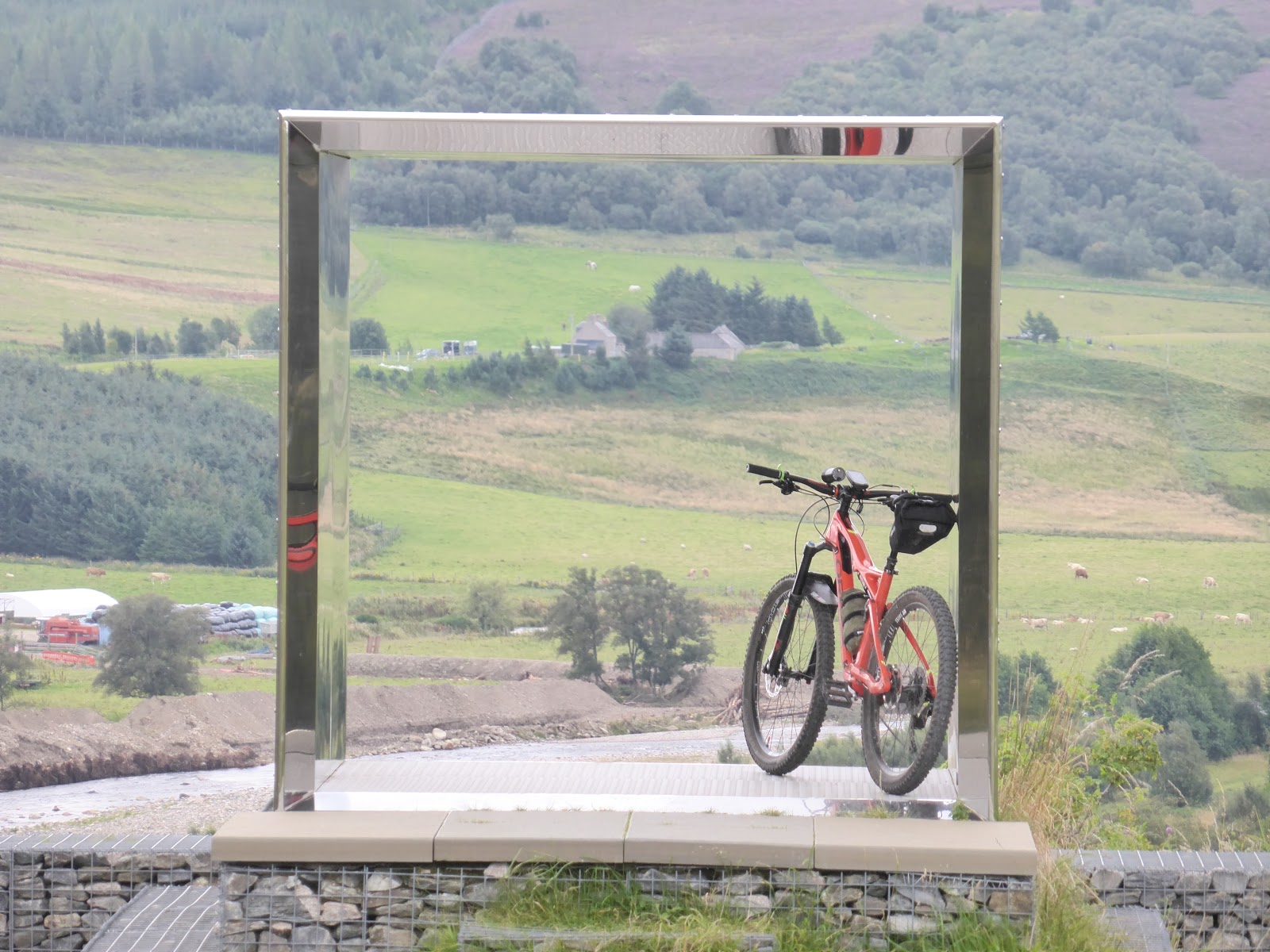
It's still dark as I pedal to the start line in the Glen Tilt car park and at 6:20 I'm on my way West, the sun slowly rising behind me. 


Once on the old road at Calvine, I switch off the lights to preserve battery power. I'm not sure how long it's going to take me for the whole route and how much night riding I'll do so it's a sensible precaution.  


Loch an DĂșin. So calm.

All the river crossings that had troubled us pass without incident and I'm able to pedal straight across, hardly getting my boots wet. It's not as warm as had been forecast though with the temperature inversion and I'm still riding with my jacket on.


Glen Tromie and Speyside ahead.

I'm easily in Glenmore in time for lunch. This is the last provisions stop for quite a while but, despite feeling quite hungry, I can't quite force it all down. No matter, I set off along to Bynack Stable and the big climb up Bynack Mor. This would usually be mostly ridable but I'm being very wary of the type of short-sharp power needed to get up the steeper bits and opt to preserve myself for the more spinny bits of the route. It's a lovely clear day, wall to wall sunshine, but as I climb I can feel that Southerly wind getting stronger and it's a real struggle across the plateau before dropping (carefully) down the first decent.


Looking North after the big climb

There's a rough banging noise and I realise that the clip holding my saddle bag on has come undone. I put it back together but it only lasts a few minutes. After three attempts I use one of the FixPlus straps I'd packed for contigency. No shame to Ortlieb for the clip failure either. the bag is at least 10 years old and I don't think they had this type of terrain in mind when they designed it.

Shortly later, when I'm pushing a little, my rear wheel jams. Expecting to see a piece of heather caught in it, I actually see one of my armwarmers. It has somehow fallen out of my rucksack. It's twin is nowhere in sight though.

The riding along here is a bit on and off and I'm happy to see the Fords of Avon refuge. The Fords themselves are remarkable. The water level is so low that I make it across on the stepping stones.There's a first time for everything!


Water levels at Fords of Avon were remarkably low.


There's a lot of this boulder field to be crossed before Glen Derry

There's a lot more pushing and shoving to clear the Lairig an Laoigh before I finally reach the easier tracks in Glen Derry. The colours here are amazing as the sun is turning the corner and hiding behind Derry Cairngorm. 


An old pine in Glen Derry catching the last of the days rays.


I'm particularly relived to reach Derry Lodge and get a chance to spin along the track and then the road Westwards, partially shielded now from the wind. I stop at the Red House for a bit of a breather and some food before hitting the watershed but the wind has suddenly dropped and the sun is setting so midges appear from nowhere and I'm forced to hurriedly put the backpack back on and set off.


More beautiful colours and I'm aware I've been on the go a whole day.


The Eidart bridge. It feels a bit precarious even in daylight.


I was so pleased to see this wee guy as I was riding. Made me feel less lonely!

I'd fully expected to be doing all of this bit in the dark so I end up making better progress than expected. I'd sort of imagined getting to Ruigh Aitchechean bothy around midnight but it's clear I'm ahead of that schedule. Just as the path starts to improve I hit a deep mud hole and land sideways. My right leg has disappeared up to the thigh in thick mud and the bars of my bike are buried in it up to the stem. Grabbing handfuls of wet moss, I attempt to wipe it all down. I make some improvement, at least restoring my ability to grip the bars and use the controls. 

On reaching the bothy, I decide to press on. I know it's not long to Aviemore now and a chance for some hot food at the 24 hour filling station. I'm also on "local" territory again so I know what to expect, where the hills are and when to make up a bit of time. Passing the Old Bridge Inn, I see they are still serving. Without a second thought, I park the bike and dash in for a cold lager. 


Midnight at the oasis

This is just surreal. I'm sat in my local, drinking beer, half way round an ITT!! 

Thoughts now are of food and finding somewhere to get the head down. The M&S at the filling station supplies coffee and a toasty which I consume while the drunks from the pubs are queuing up for their own refreshments. The temperatures are dropping rapidly too so I don't hang about too long and start to consider where to stop. I briefly consider switching my tracker off and just going home but that would be cheating :-)

I know of a nice wee spot by a loch but I also know that it'll be very cold there due to the water. As I'm making my way towards Forest Lodge, the road climbs away from the river and, as it does so, I start to pass through little bubbles of warmer air. One of these coincides with a small clearing so I step off the bike again, pump up my air mattress, lay out the SOL Escape bivvy bag and just crawl straight in. I'm damp, a bit chilled and tired but I reckon this'll do for a break. It's just after 2am so I set my alarm for 5am.

It doesn't take me long to drop off to sleep but I awake with bright moonlight on my face. Checking the time, it's just after 4am and I've gotten a wee bit colder. Rather than dig out warm or dry clothing I decide to pack up and set off, target Tomintoul.


I'm 30 minutes early for breakfast at the Richmond Arms so I head for the public toilets to get cleaned up a little. I manage to get the worst of the mud off and try to look a bit more human so as not to upset the hotel residents over breakfast. The staff are on to me though and sit me through in the bar area away from the other guests! 

Despite being aware that I need to keep my energy levels up I actually struggle with the full breakfast and just can't eat it all. I still have lots of snacks with me though and I know that I will make Braemar by late afternoon.

Setting off up Glen Avon the winds are now ferocious. It's a lovely glen but there is no shelter and I'm often struggling to make progress. The climb up to Loch Builg has me off the bike again after being blown off sideways a couple of times. 

Glen Avon. Lovely to look at......


....can't see the wind though!

There's no respite either on the climb up Culardoch. I'm forced to count a few steps, stop, re-start until I eventually see the slope levelling out and the view over to Lochnagar. What follows should be a fast downhill but I'm aware of the cross-winds now so I have to rein it in a bit. After another climb I hit the pine woods and then the main road for a tired schlepp into Braemar. 


Culardoch climb complete

Lochnagar - and about as much cloud as I saw over two days.

At this lower altitude, and with the shelter of the buildings, it has suddenly become much warmer but I opt to get out of the sun and have a toastie in the Bothy Bistro. I'm sat beside the wide-open door though so any odours are at least escaping. Again, I struggle to eat much. Then I'm off towards Linn of Dee again. There is more shelter here so I'm out of the wind and it's really very pleasant. Part of me wants to stop, maybe overnight, just to rest and enjoy the evening. However, I'm not carrying enough for a comfortable long stop so it's time to crack onwards.


Obligatory selfie


Bynack Lodge. A potential lazy stopover.
At Linn of Dee I'm back on the track I passed over less than a day before. This feels a bit weird, like I'm doing laps of some huge race, but at the Red House (no midge this time) I cross the Geldie and start my way south - back into the headwind - again. The top end of the Glen is fine but as the Tilt develops the track deteriorates again and I'm simply too tired to deal with it. Again, I'm reduced to pushing the bike, maybe getting on for short sections.

And then there's the "sting in the tail". A less sadistic route-setter would have ended the circuit by heading straight down the Tilt to Blair Atholl on a good, fast track. Steve Wilkinson isn't that man though and It's off up to Fealar Lodge after crossing the river. I'm reckoning on this taking up to 5 hours on account of my fatigue and give myself a wee target of trying to be back at the van by midnight.  I'd completely forgotten how steep the climb out of the glen is and it's a case of pushing up a metre or so, then stopping, then pushing, then stopping. When the track flattens out a little I can see the good estate road I'll be on but it's a long and frustrating detour to get to it. Once there though, I'm slightly happier. At least I can mostly ride now, despite the further climbs. Hitting the Allt Fearnach descent gives me a huge buzz. Suddenly I'm moving very quickly and closing the distance between myself and the end of the loop. I'm very glad of having full suspension too as I'm getting tired and lazy and I can just let the bike handle all the rough stuff. 

Turning Westwards at Daldhu the sun has set again and It's back to using the lights. I'm happier to up the power levels though as I know I'll have enough juice to get me back to the van. Inevitably, I'm again forced to push uphill and then I seem to struggle to find the turn-off I need. I keep looking at the GPS, and it's clearly marked on the map, so I ride a while, check the GPS and I don't seem to be any closer. It's frustrating and I reckon my mind is just now starting to struggle. Eventually, I see the turn off and head down towards the river crossing. My exuberance is too much and I have another over-the-bars but land on the heather, cushioning any damage. This is stupid. I'm within just a few km of the end so risk-taking really isn't warranted. 

The final climb gets me to a new piece of hard-packed track and from there it's another fast descent past the weirded-out fishers at Loch Moraig, onto the tarmac and the final couple of twists and turns down to Blair Atholl.

The route officially ends at the railway station so I head straight there to get a customary selfie with the station clock. When I look at the photo I see it's around 10:20 so I convince myself it's not been re-set since the start of BST. Only when I check the time again on my phone do I see that's it's actually correct and I'd made it back much quicker than I'd expected.


Aye - it's all smiles now....


That's a pretty significant tick in the box for me. I've upped my mileage this year, refined my kit list and even opted to change bikes for this one. Making it back in just under 40 hours was as much (more) than I'd expected. I was frustrated by the wind, which never really seemed to work in my favour and struggled to eat properly. I also think I made some sensible tactical decisions - like not pushing too hard on the difficult trails and saving my energy for the fast ones. 


A ready-reckoner for a tired mind
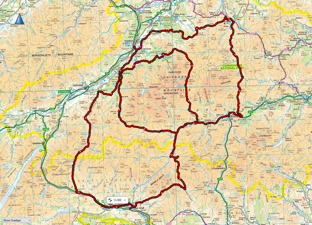
301km, 4,866m of ascent


I reckon my next trip might involve quiet roads, B&Bs and pubs...

More info on the Cairngorms Loop route and the "rules" around self-sufficient bikepacking ITTs can be found here: http://cairngormsloop.net/

Big thanks to Steve W for having the foresight to set this up.

And the best bike for bikepacking is....

The one you already own…

It’s a bit of a meme, I know. Oft asserted by the old hands who have carefully built up their bike collections and have a bike for every possible niche.

For a bit of a change, I thought I’d go against the grain a bit and do away with that, choosing to take out my “Less than appropriate” Orbea Occam on a trip I’ve been thinking about since I moved to Aviemore 6 years ago. Simply enough, it’s 50km to the trail centre at Glenlivet, so ride there, bivvy, do the red descent, then ride home.

To help with the load bearing, I fitted a Gorilla Cage to the one set of bottle mounts on the frame. That gave me some storage space low down. My insulated jacket squeezed into a small drybag there. I also fitted an old Ortlieb 3L saddle bag that I bought years ago for commuting. That held a couple of inner tubes, tool, levers, some snacks and a few items of clothing I might want through the day. Having packed those, the rest of my overnight kit went in a 25L rucksack. It was by no means full and the weight wasn’t so great as to feel uncomfortable.


It’s a fairly well-kent route, heading up past Ryvoan Bothy, past Dorback Lodge and on to the Burn of Brown.


The trails were all very dry and I managed to make all the river crossings dryshod. However, at this point, disaster struck. A bottle of Smidge I’d been carrying in the side pocket of my rucksack had bounced out. This was potentially the end of my ride. Bivvying with just a tarp and no midge protection at this time of year was likely to be fatal. A quick check of the time and I reckoned I might just make it to the one shop in Tomintoul before it closed – though I had no idea what time that was. What had been a leisurely ride became a sweaty race and I pulled up to the Tomintoul Post Office at 18:05. Thankfully, they were still open and I managed to come away with a bottle of Jungle Formula.

I was now desperate for food and drink so popped into one of the hotels for a cold beer and some hot food. I made the mistake of taking my GPS with me and, when browsing through the maps, came up with another option for the night – to head to Faindouran with a view to the Fords of Avon and Loch Avon in the morning and a climb up Coire Raibert to get back home. This was only really an option due to my choice of bike and carrying most kit in my rucksack. The thought of lugging a laden bike up Coire Raibert would never have occurred to me.

In the end, I opted to stick with Plan A. There is something particularly refreshing about camping high. As I left Tomintoul, dusk was settling in and I took the Speyside Way to the top of Carn Daimh. Given previous experience with other sections of the Speyside Way, I should have known better…

I was suckered in at the beginning as there has obviously been some recent pathworks on this section. This flock of sheep were certainly making good use of it.


After that, it did the SSW trick of running around field margins over tussocks, before making a beeline up a hill. I was just able to keep enough momentum going, particularly thankful for the rear suspension. As I climbed, the sun was just beginning to dip below the nearby hills.


 By the time I made it to the summit, the sky had become a deep red.


Despite the quite fierce wind, I hung around sheltered by the viewpoint as the world around me went dark. It didn’t look like the wind was about to drop any time so I headed downhill into the lee and came across a great little spot for my tarp. As I was setting it up, the wind DID drop and I was suddenly engulfed by the flying hordes. I scrambled to put on a midge hood and leg warmers and considered decamping to the top of the hill. However, the lull was only brief and the wind picked up again, just as strong. Decision made, I was here for the night.


I had a pretty good nights sleep. One pee break at 2am, then an alarm call at 5:45 for the dawn. It was overcast and dull so nothing to write home about. Another nap ensued before I packed up and headed to the top of the red trail.


Not my fastest descent and the amount of seat drop I could manage was limited by the bag I’d fitted, but great fun and even better knowing I’d not have to take that dumb-assed route back to the trail head. Instead, I headed back to Tomintoul for breakfast.


After breakfast, the route back also gave me the opportunity to stop at the viewpoint I’d had to speed past the night before, en route to the shop and midge salvation.


I wasn’t the only busy soul around, especially now that the heather is in full bloom.


So, a great trip. Proof enough for me that you don’t need to spend a couple of thousand on Ti-framed, B-Plus bikes with expensive, niche bags (though feel free to do so). If I lost out on some road/gravel sections, I certainly made up for it on the fun singletrack and descents. There are also other routes (like my Loch Avon idea) that suddenly become a lot more do-able. My one piece of advice though would be to, instead, spend some of that money on lightweight overnight kit. Once you can cut the weight and bulk, opting for a rucksack is nowhere near as bad as it might be (and I’ve made that mistake in the past).


Of course, I’m probably now blacklisted by the Guild of Bikepackers for my heresy, but at least my Orbea is in British Bikepacking Orange 🙂


Wednesday 15 May 2019

May Summit Bivvy

Well, the weather has certainly been somewhat variable. Late snow falls and then a mini-heatwave gave me the idea of doing a high bivvy I had promised myself over the winter but had somehow never fitted in. 

I left around 17:30 in scorching heat and headed up towards Glenmore when I bumped into Neil out for a wee spin and he accompanied me for a bit of a chat (and was on hand to take a photo of/for me). 


Once at Glenmore, the hard work begins so it was a grind up the ski road to the Sugar Bowl car park then up the old zig-zags and thence to the car park.  


I made an effort to cycle up the main access track as much as I could but it's incredibly dry and dusty so traction was almost impossible to find. Luckily, I didn't have to cross any snow until past the Ptarmigan. What little there was created a bit of extra drag on account of it being so soft. With time in hand, I made it to the summit and worked out where the best shelter would be. 


I found a wee spot in amongst the rocks and laid out my bivvy bag, mat and sleeping bag before getting some water on for some soup. It was very relaxed, with only the occasional whirr of the Automated Weather Station for company every 30 minutes. I hoped it wouldn't be so loud as to stop me from sleeping. 


I watched the sky gradually change colour then, just after 10, I flashed Mim with my torch a couple of times and she confirmed she could see me from our bedroom window. That was quite a weird feeling; on the one hand quite remote, but with this very strong connection to home. 


I awoke just after midnight; (1) the moon turned out to be very bright, despite the overhead haze, (2) the wind had shifted and I could now feel it buffeting my bivvy bag and trying to get in the top and (3) my bladder was crying out for relief. The latter made up my mind. I quickly exited the bag, did the necessary, then picked up the bag and moved it round a bit to a big rock shelf I knew from a previous bivvy. However, I was now even more under the glare of the moon. Luckily, my hat was big enough to roll it down and cover my eyes. Though I could still hear the wind, I was now well out of it and settled back to sleep.

By 3:30 or so, the wind had turned again, strengthening too, and I was getting more buffeting which was also cooling me down quite a lot. I now faced the bivvy-dwellers dilemma - get more sleep or stare transfixed at the developing colours in the sky. 


After a while, I cooried down, knowing it wasn't too long before sunrise. At 4:30 I had the water on again for coffee. I've been experimenting with meths stoves recently, in preference to wasting partly-filled gas canisters and not had a lot of success. As it turns out, my meths was just getting too cold. This time, I had the bottle in a bag and the bag inside my sleeping bag being warmed up by my body. This worked a treat and it lit first time. 


After watching the whole of the north-east sky turn a flaming red, the sun eventually burst through and I could immediately feel some warmth from it. 


Packing away my gear, I took the mat out of the bivvy bag and found that the bottom of it was absolutely drenched through condensation. I guess an indication of (a) how cold the rock had been and (b) how well the mat worked given I had been warm enough on it all night. 

The return trip through Glenmore highlighted just how cold it had been, with frost on some of the parked cars. Back in the sunshine, however, it was again very pleasant.


Oh - and no midgies or ticks! This summit camping has much to recommend it.


Saturday 22 July 2017

So Low


In the whole spectrum of mountain bike riding, I guess bikepacking is seen as the safe, bimbly cousin of the likes of Enduro. Yet here I was, cold, wet through, hurtling down a steep gravel track in the middle of the Highlands as fast as I possibly could on a skinny-tyred hardtail, loaded up with luggage and juggling the needs of speed and smoothness, in order not to get a debilitating puncture - or worse. .......


The high point of Carn an t-Suidhe looking over to Loch Ness


At the start of this year I decided I was going to stay away from year-on-year comparisons of how far I'd ridden, how many metres of ascent I'd racked up and just relax into enjoying my riding. Almost inevitably (as seems to have happened in may previous years) summer has come round and I find I'm now doing less than I was in the cold, dark months. It's like I've just got a bit bored, or just not as well organised. Couple that with the constant stream of updates on Facebook and Twittter, of posts on forums etc and I'd started to develop a bit of depression. It seemed no matter how much i wanted to get out, I always found an excuse not to. What's more, I've simply got out of the habit of doing long days and certainly not multiple long days. The sensible approach would, of course, be to build up my stamina again, with a longer term goal in mind. However, with a fairly busy July I thought I'd better get something done about my "bivvy a month" plan. Not being able to coordinate with my usual companions also gave me the opportunity to try out a 200km loop I'd been contemplating that might require a bit of experimentation and where I'd rather not drag an unsuspecting guest with me. 

The premise of the route was simple enough - use a combination of old military roads and the new(ish) South Loch Ness Trail to circumnavigate the extensive and fairly empty area of mountains known as the Monadliath. In my case, that involved starting in Aviemore and I headed out from home on tracks I know really well. 


I don't normally stop to photograph this as I see it so often!

Sweet woody singletrack

Tonights destination in the distance - under all that cloud!

Heading south through Glen Feshie and then out to Insh, I found a section of track that used to be very boggy has now been resurfaced. Perhaps as part of the Speyside Way extension to Kingussie? 

This was a bog last time I rode it.


Once at Ruthven Barracks I was now essentially following the old General Wade Military Road all the way to Fort Augustus. Evidence of the route is everywhere, the many bridges, the culverts and the straight lines. Wades men were paid by the mile and he didn't mess around with many bends!


Ruthven. The start (or end) of the road to Fort Augustus

Not heavily used, this section nut a good link between the Cairngorms Loops and the HTR 550 ITT routes.

Wade everywhere

Watching me, watching you


Across the A9 and back onto the old RoW


Looking west

Don't say you've not been warned!!

I'd been expecting rain all day and as I approached the minor road at Catlodge it put in a brief appearance before abating again. 


Orphaned bridge


Traffic jam, Garva style


However, it still looked dark and foreboding in the West and by the time I reached Melgarve Bothy it was full on. I actually considered stopping here instead of carrying on up the hill but decided that it was still too early and would give me a very, very long day 2. It got wetter and wetter as I climbed and the exertion meant I was soaked through by the time I reached the top of the zig-zags and the old hut on the col. 


Feint rainbow indicates prevailing weather at Garva Bridge

Dreich

Still dreich - but at least we're now heading down

Looking hopeful

Pizza calls!!!

I'd been avoiding looking at the time all day, preferring just to ride until I felt ready to stop but in checking the GPS, I caught sight of the Time and it turned out to be after 8pm. By now, all I could think about was getting inside somewhere for warm food and a drink, and thinking the chippy closed at 9pm, I careered down off the summit as fast as I dared. I reached Fort Augustus at 8:45, parked up the bike and presented the soggy mess I was in the chippy, taking off my wet helmet and jacket and dashing to the counter, only to be told they were open until 10!!

A huge pizza was ordered, along with both hot and cold drinks. Despite my hunger, I could only manage around half of the food but I was in no hurry anyway as at least I was warming up.


All the meat. ALL OF IT!!!!

At almost 10, I headed out into quite a pleasant evening. The clouds had all but passed over and everything smelt very fresh. 


Loch Ness

 Now I'd be following the South Loch Ness Trail to Inverness and I found the new section on the outskirts of Fort Augustus that avoids the steep road climb - not that this was any less steep. 


Fort Augustus far below already

On the new South Loch Ness Trail extension 

After a couple of miles, the track ended at a compound for the new windfarm construction and it wasn't clear how I was supposed to get back to the road. I found a watchmans hut and knocked on his window, giving him a huge fright. After pointing me in the right direction, he asked if I was stopping for the night and I replied that I'd been planning on Loch Tarff. He suggested a spot behind a large mound on the main parking layby. 


The advice was great. i was able to get right down to the lochside, taking advantage of the breeze to keep the midge at bay and I was pretty well hidden from any passing traffic. 


Night at Loch Tarff


Morning at Loch Tarff

Some early morning warmth

My bivvy spot - from the road


And looking back down to Loch Tarff


I awoke to a lovely morning and had a relaxed breakfast. I fact, I was enjoying just being there so much that I sat for much longer than usual. I'd have stayed even longer if I'd had more gas for my stove and more coffee to drink. Eventually, I got packed up and headed up the "steep" part of the SLNT to the summit of "the Suidhe" - a view that rarely disappoints. 


Loch Mhor in the distance

The SLNT markers - some easier to find than others

More evidence of Wade

Lovely old section of road - buzzards mewling on both sides as I shot this.

And some more rugged looking stuff too


From here, there's a wide variety of paths, tracks and backroads to Foyers where I arrived to find the Waterfall Cafe was open and serving breakfast. That was too much of a temptation and resulted in another lengthy halt. 


Always worth exploring if you've time - but leave the bike.

I was now faced with a choice; the official SLNT route takes a hilly and rough route to Inverfarigaig and the suggestion is that cyclists avoid the worst of this by heading along Gleann Liath. Opting for the "full experience", I chose the footpath. Having now done both options by bike, I strongly suggest the Gleann Liath variant if on two wheels.


Via ferrata - with the bike

Steep.Very steep
 Having reached the level of Loch Ness at Inverfarigaig I now had the delight of the "Corkscrew" road. It's hard to describe this. The zig-zags are steep, tight and narrow but at least have most of their complement of tarmac. Once it starts to flatten out though it deteriorates into no more than a rough farm track. However, it's an efficient way to gain height again and the climbing continued all the way up to the Fair Haired Lads Pass. From here, I was treated to a great view of Urquhart Castle and Loch Ness before once again taking my inappropriate bike down a really steep, switchback descent. 


Yes, this is a "road"

Urquhart Castle -  a view few tourists will see of it

Start of the descent to Loch Ness. Wrong bike again!

By the time I reached the lochside again I was almost at Dores and, once again, the temptation to stop was too much. This time I just opted for a cold beer and a packet of crisps but I was aware that overall I was much slower than day one.


Pint of lager and a packet of crisps please

From this......

.... to this in a few hundred metres


Another steep climb took me back onto the off-road section of the SLNT and I was eventually spat out onto the Inverness Distributor Road. This just felt weird. The vast area of tarmac seemed quite alien after two days of being almost always off-road. Before long I was at the Old Edinburgh Road and once again hooking up with General Wade towards Aviemore.


Back to Wade

Just because

Looking back down to Inverness

I'd tried this route before but was obviously much fitter the last time. The hill out of Inverness seemed relentless and I was too weary to get up enough speed to outrun the many flies that were buzzing around me. It was a relief when it finally started descending again, though the track has been gated off at one point (to be reported) and is overgrown for a short distance. 

The section round the quarry and over to Moy is mostly fine - a great place for a "gravel" bike - but the final couple of km, which is always boggy, has been made even worse with some felling under way. An alternative here would be to use the soft shoulder of the A9 for about 1km and I reckon I'd do that next time. In fact, this whole area could be transformed once the A9 dualling work reaches this section. 

Reaching NCN7 at Moy, I followed this to Tomatin for yet another break. This was when I discovered I'd left my wallet at Dores. After a moment of panic, I called the Dores Inn to find that it had been handed in. That over, I managed to pay for a drink and a bit of chocolate with my phone.

Exiting Tomatin, I was now on the only bit of todays route I hadn't ridden. It's a short section of farm track that bypasses the flooded Wade Road up to the Slochd. I expected I'd be off pushing for much of it but surprised myself with a slow, but steady, pedal up until I was higher than the main road and could, at last, see the Cairngorms in front of me.


The Northern Corries - almost home


And back to the National Park

I decided to stay on NCN 7 for a while and was soon over the lovely bridge at Sluggan. The next climb was another on which I expected to be walking but a bit of determination got me over it for the fast descent to Kinveachy. So fast, actually, that I took a wrong turn and found myself exiting onto the A9. Thankfully, the road was quiet and only a handful of vehicles overtook me before I found the crossing I'd meant to take and picked up NCN7 again through Boat of Garten and back to Aviemore.


203km / 3,745m of ascent

Having completed this loop, it occurred to me that others might want to follow suit and I thought it might be a bit of fun to give it a name - I'm thinking the Monadliath Military 200. If I get around to it, I might even create a web page with more info and a record of completions. I guess a decent time would be around 36 hours, though I really would encourage folk to take their time and explore lots of the other wee bits off-route, like the Falls of Foyers. 

The section of this route between Laggan and Tromie Bridge also provides a mainly off-road link route between the Cairngorm Loops and the Highland Trail 500 bikepacking routes should anyone want to join them up into a Scottish Highlands Mega-route!