Mostly, this is random stories from my various trips as I collect them, but I've a wee backlog to get through too and those will pop up occasionally.

Feel free to leave comments.
Showing posts with label Coast to Coast. Show all posts

Friday 10 June 2016

Act 2 : The Ride (Affric Kintail Way)

In days long past, the outdoor recreation community in Scotland would scoff at their poor cousins south of the border. "Look" we'd all say "they can only go on particular trails whereas we can go anywhere". Then some bright spark had the idea of creating the West Highland Way. "Oh no", came the cry "it'll result in walkers' (for it was mainly walkers) access being restricted and we'll be just like the English". In time, the WHW and its subsequent cousins, the Southern Upland Way, Great Glen Way and Speyside Way became an accepted part of the landscape and other Long Distance Paths (LDPs) have been springing up. One of the more recent creations is the Affric Kintail Way. Shorter than many of the others it does, nonetheless, represent a significant undertaking given that it passes through some of our most remote countryside. Casting around for a bit of inspiration to get back into bivvying and camping I considered that this might be an ideal candidate - especially once I added on a bit of riding at the start and end to make the logistics work. My plan was quite simple; head out on the Great Glen Way from Inverness to Drumnadrochit, meander over to Cannich, then head down Glen Affric for an early stop and a relaxing evening outside before heading through to Morvich the next day and riding up to Kyle of Lochalsh for the train home. The weather was looking great, the trails would be dry and I'd eventually get a chance to take the bike I'd designed just for this experience out to where it was meant to go (more on the bike in part 3).

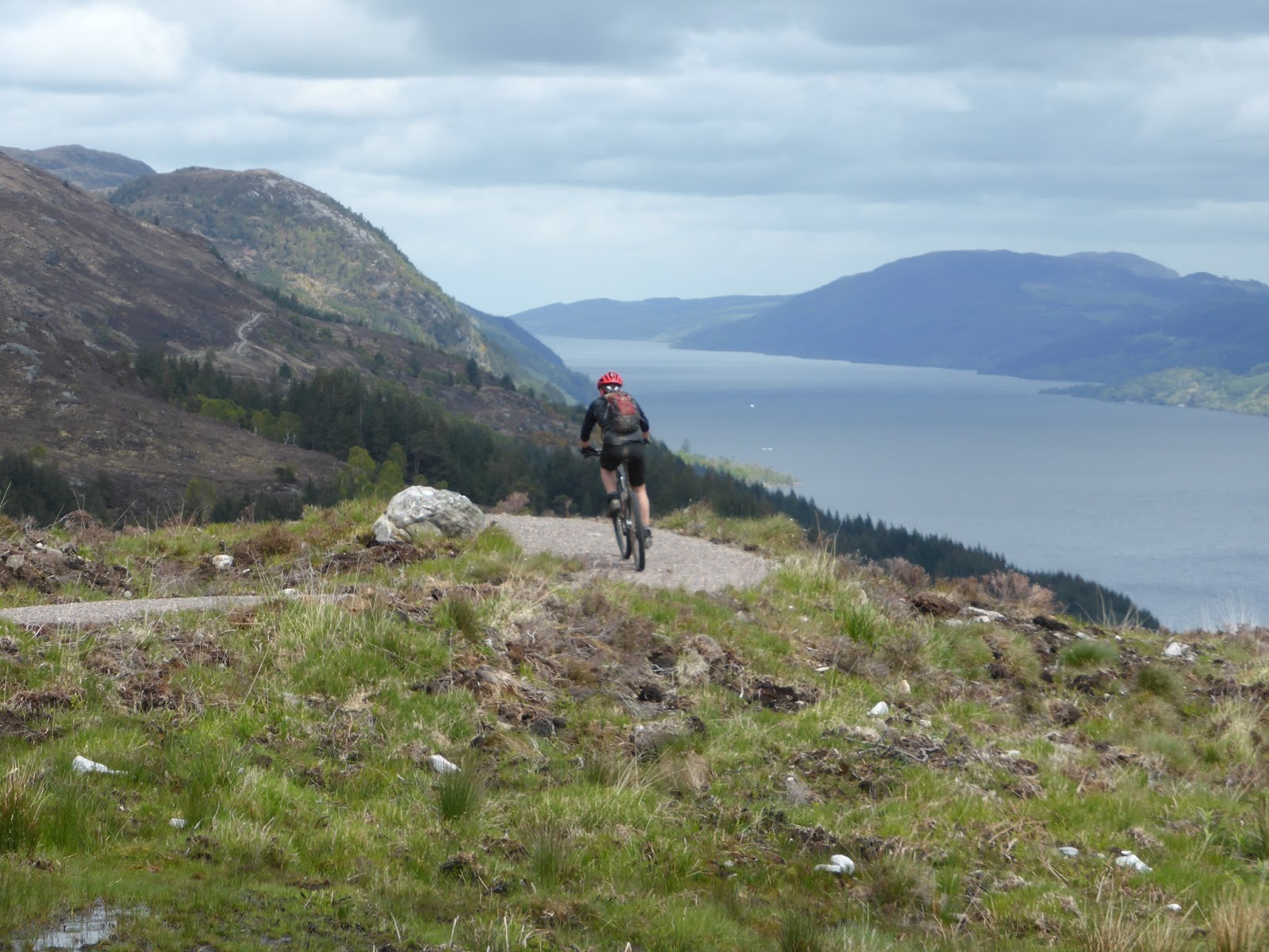
Not being in any particular rush, it was late morning by the time I headed out of "the office" in Inverness and onto the Great Glen Way. 8 degrees and misty wasn't what I'd expected but I was hoping things would improve. Having cycled down this section last year I was aware that there was a bit of a steep start and just ground my way up until the slopes levelled off and I was on to the moor at Blackfold. That's when I spotted the cyclist up ahead of me, bike on the ground and fiddling with her bag. It turned out that this was one of our customers who'd just had a puncture so I helped her get it fixed (discovering that my pump wasn't working) and sent her on her way, only to catch up again later just before the wee Eco Cafe at Abriachan. Now, I've always meant to stop on here and as the sun broke out we both pulled in for what must be Scotlands finest al fresco eating experience. I could try to describe it to you but would no doubt fail to convey it properly. You'll just have to visit for yourself.


Definitely chilled
Heading on, it wasn't long before I reached the more interesting forestry sections of the GGW high above Loch Ness. These undulate a bit but they are definitely better heading south than north! 


Quite a bit of height gain between Inverness and Drumnadrochit
A speedy descent into Drumnadrochit marked the end of the "Prologue" so I stopped for some frozen yoghurt. I also noticed that the power LED on my SPOT tracker was flashing red, meaning low battery. A visit to the local shop only turned up Alkaline in AAA size but beggars can't be choosers and they were fitted whilst enjoying my froyo.

Wandering over to the Tourist Information Centre, I had a look around to see if they had any maps or guides to the Affric Kintail Way and found a lovely Harveys map of the whole route. One can never have too many maps so this was added to my pack. 


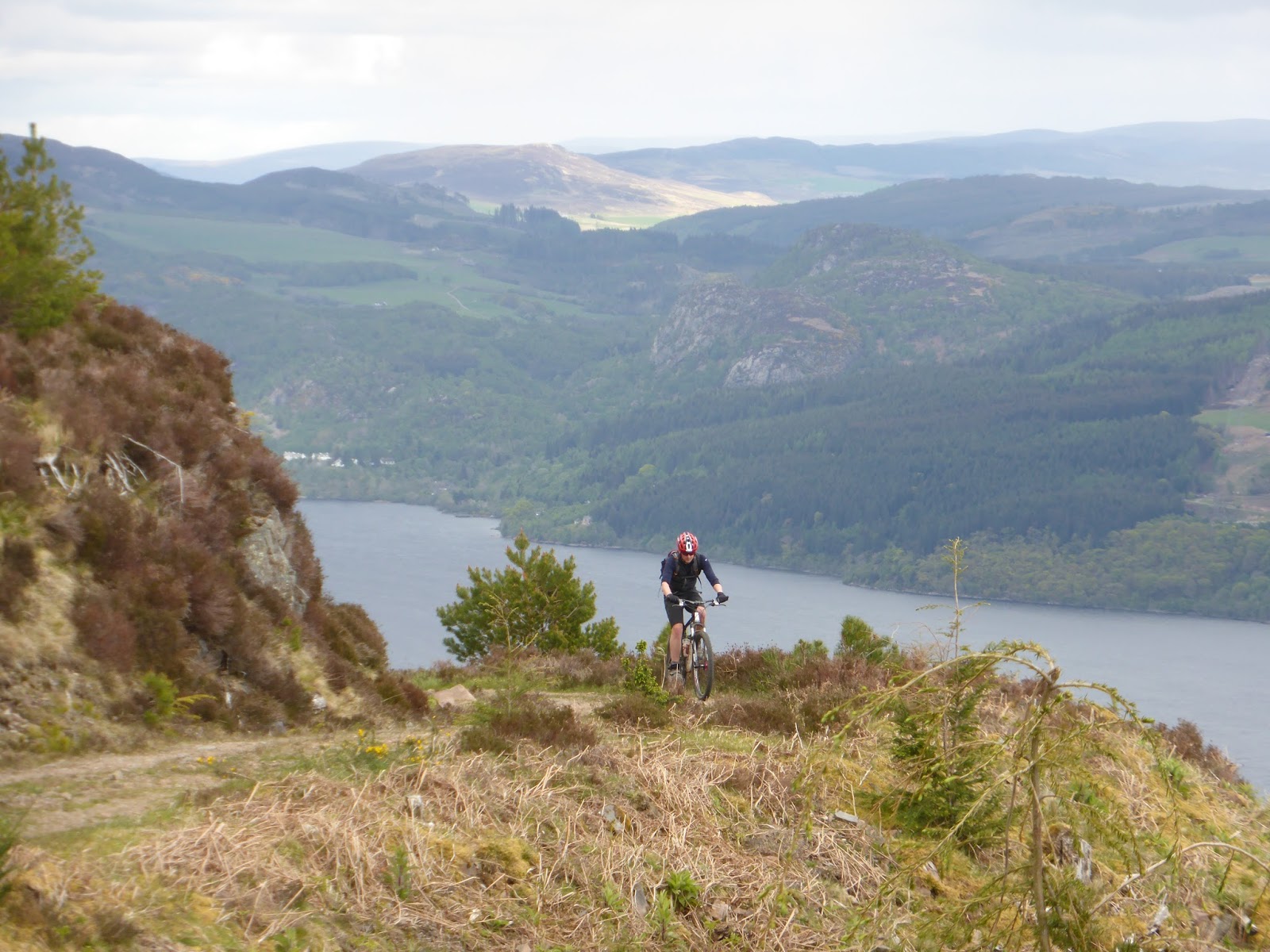
6,000ft of climbing, eh?
Whilst looking at the AKW information board, I was spotted by a hiker who'd just come through it and was concerned that I'd have a big push up the first section. I'd already spotted this on the OS map and was OK about it but we got talking about the route and my kit. As is often the case, he was astonished at how little space it was taking up and, after swapping kit details, we parted for me to head west. 

The map didn't lie. Not long after entering a pleasant bluebell woods it started to climb steeply and very loose, not helped by the dry weather.


Just before the "big push"
With a longish day in prospect I decided to take it very easy and walk where most appropriate. Eventually, it flattened out enough and I started to make decent progress. As it turned out, despite having the route in my GPS, I found there were many more tracks around than indicated on the OS map and the Harveys version I'd bought was referred to constantly.

At Corrimony, the AKW takes to the road for a few miles into Cannich. This includes a rather fast and long descent, which seemed such a shame on a mountain bike after having to suffer the climbs. I always like coming to Cannich. There's nothing particularly inspiring in and of the village itself but it does mean you're entering a stunning piece of countryside with Glen Affric, Tomich and Mullardoch all spinning off from here. It's a bit like your favourite TV show having a really naff theme tune. You might hate it but it gets you excited for what's to follow. On this particular afternoon, Cannich was hooching. There was some sort of mountain marathon event on and the place was full of campers and vans. Having plenty of time to spare, I decided I grab some food and went to the pub hoping it wouldn't be rammed with runners. I was in luck. It was rammed with drunken shinty fans instead! Still, I managed to grab a burger and chips before heading out of the village again.

The AKW climbs steeply up the Mullardoch road, before heading off on more forest track. The height gained is pretty substantial so there are some decent views for a while before the forest encroaches once more. There follows a steep descent down to cross the road at the Dog Falls but there's a strange subterranean arch on the way down that I've yet to find the purpose of. 


Not very much of this, but nice while it lasts


What's this then?

It went back further than my flash could cope with

As expected - water levels were low

Again, the track rises and I eventually reached the viewpoint looking out to the South West. It's stunning on a clearer day but even with the heat haze it's a fantastic place to sit and ponder for a while. 


Good place for a "pause"

Haze knocking back the visibility quite a bit!


By now I was seeing the tyre tracks left by the HT550 participants (who would have been going the other way) and got to wondering what state they were in (mentally and physically) when they'd passed here a few days earlier. 

As already said above, my plan had been to stop early but by the time I reached Loch Affric I was on a bit of a high. The legs were spinning, there was still loads of light, I was well fed and watered and I was getting a real buzz from just crossing the country so smoothly and effortlessly. Like an addict separated from his choice of drug for too long I didn't want to say "enough", I just wanted it to go on like this forever. I was even thinking "I'm not stopping for photos" when I'd come round a corner and just have to slam on the brakes and get the camera out.


Fantastic light in the early evening

The little oasis of Strawberry Cottage, just before the "big hills"

The far end of Loch Affric was passed, then Strawberry Cottage - looking well busy. Just after the fork in the track I saw two folk running towards me. We exchanged a few words; they were running from Morvich to the Glen Affric car park. I said they were even more mad than me but they were intrigued by the bike and that I was planning to stay out overnight. I left them to complete their final five miles and continued making my way along the bouldery, loose track.  Five minutes later and two cyclists were approaching - pushing across the boulders gingerly. They'd been up Munro bagging, so we exchanged notes on gaelic pronunciation and they too were taken by how small my load was. The more so when the woman realised I wasn't even wearing a backpack of any sort. They were also fascinated by the big tyres and their ability to cross the rocks as they were struggling and had resorted to pushing. With a few minutes lost to chat, I was again on the move, making easy progress past Alltbeithe Youth Hostel.


Alltbeithe YH. No driving to this one!

Not long after, I passed another group out camping and then I had a decision to make. I reckoned there was still enough daylight to get me past Camban and down to Glen Lichd - and potentially Morvich - but then the plan had been to camp out somewhere remote. I swithered for a while, not wanting to waste the fine night and my great mood, but eventually gave in and selected a reasonably sheltered spot just off the track and not far from the river.

Despite lack of recent practice it didn't take me long to get the tent up and my sleeping kit sorted out. I guess one advantage of having little kit is that choices are easy and it's hard to misplace anything. The ground was comfy, my pitch was well chosen and I eventually took the time to relax. It wasn't long before the cooling evening air saw me half-in/half-out the sleeping bag while I cooked up a little instant meal, which was eaten more out of a sense of duty than of hunger. I didn't even pop open the hipflask of whisky I'd brought along.


At the watershed

9pm in the Highlands in June...

It was a stunning evening though and as the stars started to show I reckoned it was late enough to zip up the midge net door of the tent and settle in for the night. It certainly didn't take me long to nod off, though I soon woke up feeling too warm and having to remove my jacket. I woke up a couple of times through the "night" too, not that it ever really got dark.

I eventually decided to get up around 5 and, still not feeling hungry, skipped the porage option for a wee cereal bar and a splash of water. Out of interest I timed myself; 30 minutes from deciding to get up I was packed and on the move. Again - little kit, little faff. The sun from yesterday was now hidden above a layer of hill mist but I had high hopes it would clear as the day progressed.

The path to Camban was a complete contrast to the easy forest track and even the bouldery stuff from Strawberry Cottage the evening before. This stuff was proper hard and rocky and made even more difficult by the fact I was climbing. Most of it was ridden - I'm pretty sure it would have made a fun descent - though the proportion of pushing was definitely increasing as the distance was covered. 


Camban Bothy appearing out of the morning mist

Past Camban bothy and the same story continued. What's more, it seemed that there were so many ups and downs. The hard geology here certainly belies the contours on the map so I was glad when the mist started to clear and I could make out both long stretches of track in front of me and the higher mountains. 


Mist finally breaking 

Yes, that's the track descending away down there...

Amusingly, the river can be seen gradually running downhill on its way West but the path keeps climbing higher and higher above the river in apparent flouting of the norm. The reason for this becomes clear when a large gorge appears on the left, with the river now tumbling down an impressive waterfall through a gap in the cliffs. 


No way down here
The path becomes quite vertiginous for a while, especially where it crosses a large landslip. Again, I was resorting to a large amount of pushing.  I'm sure that with a different bike, unladen and with company, I'd have ridden more of it but I was happy here to jump off whenever things were looking a bit too gnarly. As it went on, I could find myself getting more and more frustrated but had to fight back the urge to be too reckless.

Falling to the left would be a really bad idea

The effect of this pushing was, however, that I was now running behind my planned schedule for catching the train in Kyle. By the time I reached the estate road at Glen Lichd House, I was beginning to have serious doubts I'd make it in time. 


Glen Lichd House and the start of the estate road

Finally at valley level. A couple of nice new bridges here.

Stripping off my jacket now that the mist had completely cleared I zoomed down the glen, scaring sheep off the track, fueled by large handfuls of chocolate peanuts and the last of yesterdays energy drink. Thing was, I hadn't booked my bike on train anyway so there was a chance I'd be racing up the road for no reason!


Sea level again. That makes it another Coast-to-coast

As it turned out, I needn't have worried. I arrived with lots of time to spare and, after speaking to the driver, just loaded my bike onto the train before disappearing to Hectors Bothy for breakfast. My original intention had been to get a takeaway but I figured that the later I got back to the train, the less time there would be for the conductor to throw me off in favour of some pre-booked cyclists.

The train ride back to Inverness gave me plenty of time to reflect on my trip and such wee adventures in general. I'd definitely missed them. The difficulties of the morning had in no way diminished the buzz of the previous evening and had just added to the emotional mix. Maybe next time I'll stop earlier and relax a bit more, but then there's this other plan.........


Thoughts on the Affric Kintail Way

I'd been intrigued by this route for a while and the development of it as a signed trail definitely makes navigation of the Drumnadrochit-Cannich section a lot easier than it was just trying to follow the GPS. There are just so many twists and turns here in close proximity. I'd also pondered over what direction would be best. If relying on trains,I reckon the logistics would probably be simpler/more assured heading from Morvich to Drumnadrochit. That would mean a huge climb out of Glen Lichd of course and all of the difficult terrain would come early on. However, aesthetically and emotionally I reckon heading west, towards the larger mountains, always feels like the adventure is building rather than diminishing. Besides, travelling east it would have to be the Kintail Affric Way.....


Without overnight gear, and given two cars (or a willing driver) it could be completed in a day.  

It certainly has some full-on biking - especially the descent to Glen Lichd - some great, fast forest tracks and is always in amazing scenery. The best thing I can say about it is that I'd definitely do it again. 

You can find a lot more info on it by going to the official site: http://www.affrickintailway.com/


Download a GPX file of the route: here (Right Click/Save as...)


Friday 21 August 2015

Cycling the Great Glen Way


After completing our northerly C2C2C, Shaun and I immediately pressed on with arranging the next ride on our bucket list. This was to be the Great Glen Way, running between Fort William and Inverness. I also had a professional interest in this as we get lots of customers hiring bikes to go this route and I was curious to see exactly what it was like, having only previously cycled the section between Fort William and Fort Augustus. I was also wanting to understand why so many mountain bikers seemed to write it off, and what might be the best type of bike/tyre for it.

Our logistics this time were much simpler. Shaun would drive us both to Fort William and my wife would meet us in Inverness, ready to drive south back to Fort William.

On arrival Shaun and I set about readying the bikes. Shaun had obviously thought about the need for a little top-up of energy reserves given the time elapsed since breakfast and had brought a couple of extra cereal bars, of which he offered me one. I had also thought about this and headed for McDonalds......

The GGW makes a strange start through the streets of Fort William and Inverlochy and it's sometime necessary to differentiate between NCN78 and the Great Glen Way as you go. Of course, it's all easy pedalling out to the end of the canal, up the side of Neptunes Staircase and onto the long, flat canal section all the way to Gairlochy. For us, the weather was fine - a few puddles and a mild tailwind - but I've cycled against a howler of a wind along here and so know that the canal-side can be very exposed. 


At Gairlochy there's a short section of road before the Great Glen Way is signposted off to the left. This section, and the part by the loch that follows it, is a pleasant singletrack diversion through some lovely woods and a couple of decent picnic/bivvy spots. 


Artful angles

The road along here is signposted as NCN78 and is quiet enough too, so anyone looking to stick to easier surfaces has an option. The two options (GGW and NCN78) come together again for a short distance before both carrying on along some forest track at Clunes. This undulates enough to provide a bit of height and the occasional view along Loch Lochy before returning to tarmac at Kilfinnan.


Looks a lot like summer
It was here that I spotted two cyclists coming towards us, both loaded up with camping gear. I recognised them as participants in the Highland Trail Race and stopped for a quick natter. I think they were both surprised at the amount of attention their exploits had been achieving and as we left them to carry on South I couldn't help feeling it was putting our little expedition into some sort of perspective!

Past Laggan Locks and we were back on to the newly-surfaced NCN78. While I can appreciate the difference this makes for easier cycling, I couldn't help but look on at the old loch-side route that can often be seen alongside, gravelly, muddy and root-strewn, with a little sadness. 
It's big, but is it clever?

More angles

Just outside Fort William, we had to cross a set of locks and saw the largest boat I'd ever seen on the Caledonian Canal. We stopped for a brief chat with the lock-keeper who confirmed that it was just below the maximum dimensions for the locks - and had, in fact, been shortened as it was originally 2 metres too long. It certainly filled the lock, especially as the water level lowered.


We definitely don't need a bigger boat!

Always keen to keep the tummy occupied, it was time for a lunch stop in Fort Augustus. Luckily, it was pleasant enough outside so we commandeered a table overlooking the canal. It had taken us a little over 3 hours to reach here, despite a couple of wee stops, so I was happy that we were making decent progress. I also knew that all of the climbing was yet to be encountered so didn't want to hang around too long. Leaving Fort Augustus, it wasn't long before we encountered the first steep climb. Having already decided that we should take the High Level variation of the GGW, I knew that there would be quite a bit more climbing and wanted to make sure I had legs for the rest of the day so it was off the bike to push up for a while. A look at the figures shows that this was a 300m climb in around 5km. The big advantage of this though was that we were treated to some great views back to Fort Augustus and beyond and also up along the rest of the Great Glen. The track along here swoops over the terrain and we found it about 95% rideable, with just a couple of very steep sections to test the legs a bit. 


Dropping down into Invermoriston, the path was more reminiscent of a Blue/Red graded MTB Trail with suitably impressive drop-offs. Of course, reaching the loch level at Invergarry required another big climb out and this time there was a lot more pushing as we negotiated the zig-zags through the woods. 


High again
It would be fair to say that I was in some need of refreshment by the time we reached Drumnadrochit. Thankfully, the scones at the Fiddlers did not disappoint, coming with a massive dollop of fresh cream. I was, however, keen not to sit around too long as I know my legs get difficult to "re-start" and that there was yet another big climb coming up. In fact, Shaun almost missed the start of this one where it turns off the A82 pavement. Either that, or he was secretly trying to find a faster way to the end. The scenery hereabouts was quite different to that we'd been seeing earlier, with more farmland and signs of actual human habitation. The GGW was lovely though, with sections through a narrow tunnel of gorse and whin that swept to and fro.

Having heard about the wonderful cafe at Abriachan Woods, I was keen to try it out and all the lovely handmade signs as we approached it lent it a strange charm of its own. However, knowing the end was almost in sight, we agreed to plough on to Inverness so I'll have to make a special effort to pass this way again sometime soon. 

Having got all this way on what were surprisingly dry tracks, the wet and mud through the forest at Craig Dunain came as a wee bit of a shock. It certainly went some way to explaining why so many of the bikes I see arriving in Inverness are filthy. Coming into the suburbs of Inverness, the GGW gets a massive amount of signposting to take into account the various streets and paths meaning we had to pay a bit of attention lest one be missed. 

Finally crossing through the Ness Islands left us with a wee carry up some steps to get onto the last wee kicker to the castle and the official end of the GGW. 


So, that was the Great Glen Way. Having completed it, I can honestly say it's a great route. The new high level sections obviously make it more of a challenge (in fact, I'm now planning to do the low level options to see what they are like) and it felt like a perfect, long day out in the hills. 


Channeling Vitruvian Man

The figures show we did 119km with 2,148m of ascent. We were riding for just under 8hrs30m.


A ride of two halves!

Thursday 9 July 2015

Not quite idle

I could just pick up where I left off with this blog and just pretend I've been incarcerated or in a coma for the past six months but the truth is I've simply been too lazy to do any updates. It's a shame really; this winter Mim and I really got into the skiing on Cairngorm and made good use of our uplift passes and the ski gear we bought at Decathlon. We're even thinking of a little foreign skiing trip later this year in order to develop our new skills. On the cycling front, I started to build up my fitness again after double illness finished off 2014. However, with no "events" planned I found it a bit tougher to keep up momentum so I decided to make some commitments as a bit of an incentive. The main part of this was to set out a list of longer mountain bike rides I'd been thinking of and had previously been discussing with Shaun. We'd both meant to get some of these done last year but time just seemed to fly by too fast so 2015 was going to be the big year.

The first on our list has been on my radar for several years since I read about it on a now defunct website that had all sorts of wilderness mountain biking routes. It's the northern coast-to-coast, from Ardgay on the East to Ullapool on the West. Now, the problem with most C2Cs is the logistics. How are you supposed to get back to your start point if you've just ridden across the breadth of the country - especially in the Scottish Highlands where roads are few and circuitous and public transport is almost non-existent? In this case, the answer is pretty simple - just turn around and ride back again. Yep, this little coast-to-coast rocks in at a mere 59km each way making a C2C2C possible. 

Courtesy of an early start from home, we were in Ardgay ready to set off at 8am. A good few miles of tarmac at the Ardgay end gets you to Croik and its church before you head off onto estate road. 


No more tarmac
We were blessed by a bit of a tailwind along this section and made decent time, passing massive herds of deer, though we were confused by the topology and kept expecting some sort of steep climb to get out of Strath Cuileannach. Although it never really came, there was a wonderful moment topping the crest of a rise to be greeted by the view of Suilven in the west. 


Feels like the West Coast now
Suddenly, it felt like a "proper" mountainbike adventure. The track between here and Loch Achall is of varying quality and is obviously prone to a bit of flooding but we were fairly lucky with the conditions and it was a while before one rock-strewn puddle had us both off the bike. A few metres later, I discovered this little aquatic incident had knocked my mech hanger out of alignment as I was struggling to get any clean gear changes. Concerned that bending it back might snap it and being foolish enough not to have brought a spare, I had to make the decision whether to turn back now, less than half way across the country, or nurse  it through for the rest of the day. I opted to carry on, trying to avoid changes where possible and crunching through a few others. 

By the time we reached the last, steep, descent into Loch Achall the wind had picked up a wee bit more and we flew along the side of the loch to the quarry track and the short road ride into Ullapool. 

Lunch was a fairly relaxed affair. We'd arrived ahead of schedule and had no need to hurry back. However, it's never a good idea to let the body think the days exertions are over prematurely so it was back up the hill to start the return journey. Of course, what goes around comes around and the wind now presented a stiff obstacle. The climb after the farm at East Rhiddoroch Lodge was going to be a challenge in the best of conditions but this reduced it to a walk. Once the track levelled out though, we were able to make decent progress again. Just chatting to Shaun on one of the steeper ascents, I heard a bang and suddenly saw his feet spinning wildly. Irony of ironies, it was his chain that snapped, not my gear-tortured one. A few minutes with a chain tool had it a link shorter (it was humongously long anyway) and we were both underway again.


Maybe I need to invest in some brighter clothing?
While we had a wee stop (not a wee stop) beside the bothy at Duag Bridge we got chatting to a Dutch couple who were touring the area on hybrid bikes and who'd got stuck on their way out of the bothy that day, not really being prepared for the deteriorating state of some of the tracks. We passed on a bit of advice, suggesting they could make Ullapool the way we'd come if they were prepared for a bit of pushing in places.

We almost missed the climb after the bothy as it's on a minor track and we were "hurtling" along a better one. However, a small bit of backtracking got us sorted and once that climb was out of the way it seemed it would be only minutes before we were back at Croick and then Ardgay. These assumptions turned out to be false as the glen seemed to have been seriously extended in some unknown but fast-acting geological progress (OK, maybe it was a combination of headwind and tired legs). I was certainly glad to see the outskirts of Ardgay again and fall into the van almost 11 hours after we'd left.


No caption necessary
Not a bad day all-in-all. If not technical it was at least an enjoyable day exploring an area most won't see and getting a fascinating view of some mountains from an unusual angle. The Coast-to-Coast thing adds another angle and I'm already thinking of another, a bit further South.


Straightforward enough