Mostly, this is random stories from my various trips as I collect them, but I've a wee backlog to get through too and those will pop up occasionally.

Feel free to leave comments.
Showing posts with label General Wade. Show all posts

Friday 21 August 2015

Cycling the Great Glen Way


After completing our northerly C2C2C, Shaun and I immediately pressed on with arranging the next ride on our bucket list. This was to be the Great Glen Way, running between Fort William and Inverness. I also had a professional interest in this as we get lots of customers hiring bikes to go this route and I was curious to see exactly what it was like, having only previously cycled the section between Fort William and Fort Augustus. I was also wanting to understand why so many mountain bikers seemed to write it off, and what might be the best type of bike/tyre for it.

Our logistics this time were much simpler. Shaun would drive us both to Fort William and my wife would meet us in Inverness, ready to drive south back to Fort William.

On arrival Shaun and I set about readying the bikes. Shaun had obviously thought about the need for a little top-up of energy reserves given the time elapsed since breakfast and had brought a couple of extra cereal bars, of which he offered me one. I had also thought about this and headed for McDonalds......

The GGW makes a strange start through the streets of Fort William and Inverlochy and it's sometime necessary to differentiate between NCN78 and the Great Glen Way as you go. Of course, it's all easy pedalling out to the end of the canal, up the side of Neptunes Staircase and onto the long, flat canal section all the way to Gairlochy. For us, the weather was fine - a few puddles and a mild tailwind - but I've cycled against a howler of a wind along here and so know that the canal-side can be very exposed. 


At Gairlochy there's a short section of road before the Great Glen Way is signposted off to the left. This section, and the part by the loch that follows it, is a pleasant singletrack diversion through some lovely woods and a couple of decent picnic/bivvy spots. 


Artful angles

The road along here is signposted as NCN78 and is quiet enough too, so anyone looking to stick to easier surfaces has an option. The two options (GGW and NCN78) come together again for a short distance before both carrying on along some forest track at Clunes. This undulates enough to provide a bit of height and the occasional view along Loch Lochy before returning to tarmac at Kilfinnan.


Looks a lot like summer
It was here that I spotted two cyclists coming towards us, both loaded up with camping gear. I recognised them as participants in the Highland Trail Race and stopped for a quick natter. I think they were both surprised at the amount of attention their exploits had been achieving and as we left them to carry on South I couldn't help feeling it was putting our little expedition into some sort of perspective!

Past Laggan Locks and we were back on to the newly-surfaced NCN78. While I can appreciate the difference this makes for easier cycling, I couldn't help but look on at the old loch-side route that can often be seen alongside, gravelly, muddy and root-strewn, with a little sadness. 
It's big, but is it clever?

More angles

Just outside Fort William, we had to cross a set of locks and saw the largest boat I'd ever seen on the Caledonian Canal. We stopped for a brief chat with the lock-keeper who confirmed that it was just below the maximum dimensions for the locks - and had, in fact, been shortened as it was originally 2 metres too long. It certainly filled the lock, especially as the water level lowered.


We definitely don't need a bigger boat!

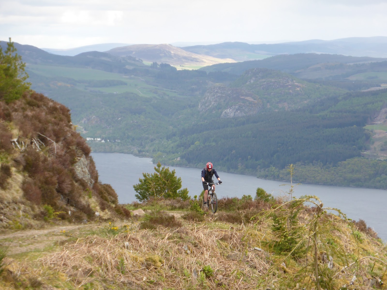
Always keen to keep the tummy occupied, it was time for a lunch stop in Fort Augustus. Luckily, it was pleasant enough outside so we commandeered a table overlooking the canal. It had taken us a little over 3 hours to reach here, despite a couple of wee stops, so I was happy that we were making decent progress. I also knew that all of the climbing was yet to be encountered so didn't want to hang around too long. Leaving Fort Augustus, it wasn't long before we encountered the first steep climb. Having already decided that we should take the High Level variation of the GGW, I knew that there would be quite a bit more climbing and wanted to make sure I had legs for the rest of the day so it was off the bike to push up for a while. A look at the figures shows that this was a 300m climb in around 5km. The big advantage of this though was that we were treated to some great views back to Fort Augustus and beyond and also up along the rest of the Great Glen. The track along here swoops over the terrain and we found it about 95% rideable, with just a couple of very steep sections to test the legs a bit. 


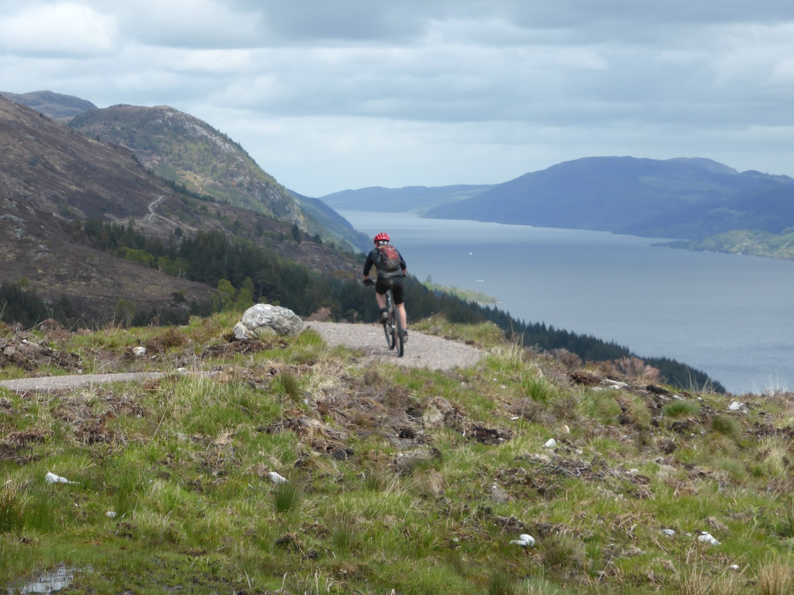
Dropping down into Invermoriston, the path was more reminiscent of a Blue/Red graded MTB Trail with suitably impressive drop-offs. Of course, reaching the loch level at Invergarry required another big climb out and this time there was a lot more pushing as we negotiated the zig-zags through the woods. 


High again
It would be fair to say that I was in some need of refreshment by the time we reached Drumnadrochit. Thankfully, the scones at the Fiddlers did not disappoint, coming with a massive dollop of fresh cream. I was, however, keen not to sit around too long as I know my legs get difficult to "re-start" and that there was yet another big climb coming up. In fact, Shaun almost missed the start of this one where it turns off the A82 pavement. Either that, or he was secretly trying to find a faster way to the end. The scenery hereabouts was quite different to that we'd been seeing earlier, with more farmland and signs of actual human habitation. The GGW was lovely though, with sections through a narrow tunnel of gorse and whin that swept to and fro.

Having heard about the wonderful cafe at Abriachan Woods, I was keen to try it out and all the lovely handmade signs as we approached it lent it a strange charm of its own. However, knowing the end was almost in sight, we agreed to plough on to Inverness so I'll have to make a special effort to pass this way again sometime soon. 

Having got all this way on what were surprisingly dry tracks, the wet and mud through the forest at Craig Dunain came as a wee bit of a shock. It certainly went some way to explaining why so many of the bikes I see arriving in Inverness are filthy. Coming into the suburbs of Inverness, the GGW gets a massive amount of signposting to take into account the various streets and paths meaning we had to pay a bit of attention lest one be missed. 

Finally crossing through the Ness Islands left us with a wee carry up some steps to get onto the last wee kicker to the castle and the official end of the GGW. 


So, that was the Great Glen Way. Having completed it, I can honestly say it's a great route. The new high level sections obviously make it more of a challenge (in fact, I'm now planning to do the low level options to see what they are like) and it felt like a perfect, long day out in the hills. 


Channeling Vitruvian Man

The figures show we did 119km with 2,148m of ascent. We were riding for just under 8hrs30m.


A ride of two halves!

Friday 24 October 2014

Looking for Wade again

Anyone who has spoken to me about my wanderings round Scotland, or has read this blog for a while, will know of my fascination with old routes. There's something about the history of them and the decisions that were involved in their creation and direction that catches my imagination. Amongst the most evocative are the old "military" roads mostly ascribed to General George Wade, but often created by his successor, William Caulfield. Many of these old roads still follow the most "logical" way of traversing the countryside and so remain an excellent resource for those of us on foot or cycling and who wish to avoid the modern highways. 

I've recently been looking for  a good off-road route from the Cairngorms into Inverness and it was inevitable that the old Wade road would come into my sights. I'd also been asked by Scotways to report back on the current condition of the road north of Moy so I had an ideal incentive to undertake a bit of surveying. 

I've previously written about the section of road from Aviemore to Tomatin here. In essence, it all works really well as a walking or cycle route until the downhill section into Tomatin. Here, the old road is completely overgrown and moss-filled requiring a short detour over the adjoining fields.

From Tomatin, the old road has been almost completely overlaid by the railway and the various alignments of the A9 until the small village of Moy is reached. From here, the start of the route is handily signposted and goes to Lynebeg and Lynemore via a crossing of the A9. 


Local news beside the Right of Way signs

There is an official crossing point, but take great care
After a short distance on a good track, the Wade road can be seen heading off to the right. It's little more than a depression in the ground in some places and where there is an embankment on both sides the inability of water to drain away has resulted in some significant standing bogs - mostly quite shallow though. 
 
Take the right-hand track at Lynemore (NH762339)


The line of the road is obvious (even when waterlogged) and can be seen on the hill beyond

When the forest becomes more visible the gate ahead allows access into a narrow clearing. Just before this meets another good forest road, it's necessary to cross a wee burn. There are no obvious signs of a bridge here so there's a chance that the burn has swollen beyond its previous flow as a result of the surrounding forest. 


The gate is fairly obvious as is the clearing behind

No sign of an ancient bridge here where the clearing ends and joins the new track (NH748343)
The new track now hides the original surface from use but it's a good route, high enough up the hillside to give some airy, open views. 

Staying right parallels the modern A9

A cairn to mark the Rout of Moy (at NH 730347)

Around midnight on 16th/17th February 1746, Lord Loudon, the Commander of the Hanoverian forces in the north, mustered 1500 troops from the Inverness Garrison and set off on the twelve mile march south along General Wade’s Road to Moy in a bid to capture Prince Charles Edward Stuart. The prince, a guest of Lady Anne Mackintosh (Colonel Anne) at Moy Hall, had arrived with a small guard of 50 men, some distance ahead of his retreating Highland Army.

Pitch darkness interspersed with flashing lightning slowed and unsettled the marching men.

Watching the road here, 3 miles from Moy Hall, was an ‘outer guard’ of just five Jacobites led by Donald Fraser, the Moy Blacksmith. He had chosen a spot where he could observe movement on the skyline to the north in darkness, and where he had cover to the south in daylight. Nearby to the east, peat stacks remained out on the moor. Here he planned to harass, and perhaps deceive, the enemy.

As the Hanoverian Column, spearheaded by the Laird of MacLeod and his men approached in the darkness, they were surprised by sudden musket fire and loud war cries urging clansmen to battle. Even the peat stacks threatened in the flashing lightning. Convinced that the whole Highland Army was at hand, Loudon’s men turned in panic and fled back to Inverness, somehow carrying off the body of Donald Ban MacCrimmon, Piper to MacLead and the only fatality of the night. A premonition of his imminent death had been realised.

As the road goes downhill again it has to veer off the Wade route due firstly to the A9 and then due to some quarry workings. For the real Wadeophiles it is, however, worth making a short detour along the original route to see the old bridge over the Midlairgs Burn. 


Wade Road on the left, modern forest track to the right (NH721359)

Lovely old bridge over the Midlairgs Burn (NH716361)

Go much past this and you'll come up against the quarry gates with their rather prominent warnings of imminent death! 


Continuing on the re-aligned road it's not long before the farmhouse at Auchbain is passed then we pick up the Wade route outside the front entrance to the quarry. 


Pretty clear

Original alignment straight on, revision to the left. There's a RoW sign hidden in this photo.....

There's a short section of tarmac, before a right turn onto the B851 road to Farr and then an immediate left to the bridge at Faillie. This is a typical, steep bridge and the road surface at the summit is well marked by the passage of low vehicles. 


Faillie Bridge. Not recommended for sports cars

From here, the route gets a little difficult to find, mostly because of the recent housing developments. Eventually, I spotted a sign hidden in the bushes where the current road seems to have been widened to accommodate a lorry turning. The problem now is that there is a huge embankment to climb up - difficult enough on foot and more so dragging a bike. 


That's the RoW going up the embankment on the left. I actually repositioned the sign after this photo.

This re-aligned section carries on to the back of a modern house then joins the original route uphill through a very overgrown section between a field and a fence. It's not hard to see why this has been left to the undergrowth as the gate at the top has been locked (not sure this is legal if it's a Right of Way), thereby restricting passage. 


It was just about possible to find the track through this vegetation. The locked gate doesn't help.

With the proliferation of shrubs and long grass, combined with the steep angle, this became a bit of a push rather than a ride. Beyond this gate the track is visible as a field boundary, carrying on in a straight line to the minor road through another gate (unlocked this time).

Crossing this road there's an obvious, signed march through the woods with dykes (mostly well overgrown now) lining the route. 


Entering Dundavie and Daviot Woods
The alignment is obvious the whole way as it's almost arrow straight and continues through Dundavie and Daviot Woods on a mostly good surface until the crest of the hill is reached and there's a change in the air as you start descending to the outskirts of Inverness. 


The outskirts of Inverness and the view North


And looking South
From the top of this restricted access lane, it's a fast descent down to "civilization" and the big city. 

At the junction of the Old Edinburgh Road and Stevenson Street
All in all, I'm pretty happy with the route. If anything, I think it works better going South where the one possible pushing section north of Faillie is therefore rideable. I can imagine that the last section of singletrack into Moy itself could be horrendously boggy at certain times of year but it's all typical Scottish mountainbiking. This links up pretty well with the section from Tomatin to Aviemore, providing an almost exclusively off-road route all the way to the Cairngorms and beyond to Kingussie and Newtonmore. 

As for my day out, I really enjoyed tracking down the old road. In places, the original alignment has been bypassed altogether and is sometimes easily missed (in fact I think I've subsequently spotted an "orphaned" section on the east side of the A9 south of Auchbain). A combination of map reading, aerial photography, on the ground assessment and, sometimes, downright wishful thinking, seems to bring the route alive and it's not too hard to imagine yourself in George Wades head, seeing the land as he saw it and trying to decide where his road should go. In places, it has survived remarkably well. In others, centuries of non-use have made it almost impenetrable. Either way, it still stands as a remarkable achievement. 

Other details and descriptions of this route can also be found on the Scotways Heritage Paths website, here