Mostly, this is random stories from my various trips as I collect them, but I've a wee backlog to get through too and those will pop up occasionally.

Feel free to leave comments.

Thursday 9 July 2015

Not quite idle

I could just pick up where I left off with this blog and just pretend I've been incarcerated or in a coma for the past six months but the truth is I've simply been too lazy to do any updates. It's a shame really; this winter Mim and I really got into the skiing on Cairngorm and made good use of our uplift passes and the ski gear we bought at Decathlon. We're even thinking of a little foreign skiing trip later this year in order to develop our new skills. On the cycling front, I started to build up my fitness again after double illness finished off 2014. However, with no "events" planned I found it a bit tougher to keep up momentum so I decided to make some commitments as a bit of an incentive. The main part of this was to set out a list of longer mountain bike rides I'd been thinking of and had previously been discussing with Shaun. We'd both meant to get some of these done last year but time just seemed to fly by too fast so 2015 was going to be the big year.

The first on our list has been on my radar for several years since I read about it on a now defunct website that had all sorts of wilderness mountain biking routes. It's the northern coast-to-coast, from Ardgay on the East to Ullapool on the West. Now, the problem with most C2Cs is the logistics. How are you supposed to get back to your start point if you've just ridden across the breadth of the country - especially in the Scottish Highlands where roads are few and circuitous and public transport is almost non-existent? In this case, the answer is pretty simple - just turn around and ride back again. Yep, this little coast-to-coast rocks in at a mere 59km each way making a C2C2C possible. 

Courtesy of an early start from home, we were in Ardgay ready to set off at 8am. A good few miles of tarmac at the Ardgay end gets you to Croik and its church before you head off onto estate road. 


No more tarmac
We were blessed by a bit of a tailwind along this section and made decent time, passing massive herds of deer, though we were confused by the topology and kept expecting some sort of steep climb to get out of Strath Cuileannach. Although it never really came, there was a wonderful moment topping the crest of a rise to be greeted by the view of Suilven in the west. 


Feels like the West Coast now
Suddenly, it felt like a "proper" mountainbike adventure. The track between here and Loch Achall is of varying quality and is obviously prone to a bit of flooding but we were fairly lucky with the conditions and it was a while before one rock-strewn puddle had us both off the bike. A few metres later, I discovered this little aquatic incident had knocked my mech hanger out of alignment as I was struggling to get any clean gear changes. Concerned that bending it back might snap it and being foolish enough not to have brought a spare, I had to make the decision whether to turn back now, less than half way across the country, or nurse  it through for the rest of the day. I opted to carry on, trying to avoid changes where possible and crunching through a few others. 

By the time we reached the last, steep, descent into Loch Achall the wind had picked up a wee bit more and we flew along the side of the loch to the quarry track and the short road ride into Ullapool. 

Lunch was a fairly relaxed affair. We'd arrived ahead of schedule and had no need to hurry back. However, it's never a good idea to let the body think the days exertions are over prematurely so it was back up the hill to start the return journey. Of course, what goes around comes around and the wind now presented a stiff obstacle. The climb after the farm at East Rhiddoroch Lodge was going to be a challenge in the best of conditions but this reduced it to a walk. Once the track levelled out though, we were able to make decent progress again. Just chatting to Shaun on one of the steeper ascents, I heard a bang and suddenly saw his feet spinning wildly. Irony of ironies, it was his chain that snapped, not my gear-tortured one. A few minutes with a chain tool had it a link shorter (it was humongously long anyway) and we were both underway again.


Maybe I need to invest in some brighter clothing?
While we had a wee stop (not a wee stop) beside the bothy at Duag Bridge we got chatting to a Dutch couple who were touring the area on hybrid bikes and who'd got stuck on their way out of the bothy that day, not really being prepared for the deteriorating state of some of the tracks. We passed on a bit of advice, suggesting they could make Ullapool the way we'd come if they were prepared for a bit of pushing in places.

We almost missed the climb after the bothy as it's on a minor track and we were "hurtling" along a better one. However, a small bit of backtracking got us sorted and once that climb was out of the way it seemed it would be only minutes before we were back at Croick and then Ardgay. These assumptions turned out to be false as the glen seemed to have been seriously extended in some unknown but fast-acting geological progress (OK, maybe it was a combination of headwind and tired legs). I was certainly glad to see the outskirts of Ardgay again and fall into the van almost 11 hours after we'd left.


No caption necessary
Not a bad day all-in-all. If not technical it was at least an enjoyable day exploring an area most won't see and getting a fascinating view of some mountains from an unusual angle. The Coast-to-Coast thing adds another angle and I'm already thinking of another, a bit further South.


Straightforward enough


Wednesday 10 December 2014

Them's the breaks

Dochgarroch Locks
30th September and I'm riding along the Caledonian Canal towpath, in the dark, returning from a little exploratory ride after work. It suddenly occurs to me that it's the end of the month and I haven't been out for my obligatory bivvy. Obligatory. That's the exact thought that went through my head. I quickly considered how I could get back home, grab all my gear and head out for a wee walk or ride and complete month 21 of my self-imposed bivvy-a-month target. However, the more I thought about it, the more I came to realise that it would just have been a box-ticking exercise. Up until then, all my bivvys (or camps or bothy nights) had some sort of background to them. They were in places I'd considered visiting or had a specific view or outlook I wanted to experience. 

As a result I opted to miss this one and, having done so, seemed to somehow skip October and November too. Partly that was due to feeling a bit under the weather, which turned out to be early-stage Lymes Disease (or perhaps from the side-effects of the subsequent anti-biotics) and partly due to a general lack of enthusiasm. In any case, since November I'd been slowly working myself back up to a better monthly mileage when a comedy slide had me off the bike and I bashed my shoulder. The fall itself was nothing. A wee bit of lack of attention, a bit of pine-needle covered mud and the front wheel just slid away from me. By the time I had it back under control I was heading for the trees and I decided to bale out. Lying on the path I looked back at the bike to see it sitting perfectly balanced upside-down, as if some naughty trail fairy had tried to cover up the results of up his (or her) booby trap.


The ride back home was slow and steady as the pain gradually got worse and after a week or so of ooh-ing and aah-ing every time I reached for something or sneezed, I decided it was time to see the GP. She quickly diagnosed a broken rib (2nd or 3rd down), prescribed some painkillers and told me it would be 4-6 weeks for recovery. 

So, here I sit, watching the first decent snowfall of the season, unable to cycle, unable to ski (uplift passes are here!) and now reflecting on all those opportunities for nights out that I let slip away though delay and indecision. I guess this enforced break has at least re-kindled my enthusiasm for some more overnighting and I can use the convalescence time to start re-creating a bucket list of venues and goals. More islands I think, some more coastline and also taking some time to re-discover more old tracks now that many old favourites are being ridden more regularly. I'm not one for New Years Resolutions, but that's beginning to shape up like one.


Saturday 6 December 2014

Mix and Match

It seems to me that there has been an enormous increase in the variety of ways folk are enjoying the countryside these days. Where once upon a time we thought mainly of hillwalkers, we've seen the explosion in mountain biking, then the wave of kayakers and canoeists. Skiing became snowboarding and folk are now taking to the air in wingsuits. For some, even this isn't enough and they need to combine two or more of these activities in search of another angle. From my recent experiences, I've seen that lightweight rafts begat packrafting. Strap these rafts onto your bike as luggage and you have bikerafting. Of course, some of this has only become possible as equipment weights (and volume) have plummeted with the introduction of new materials and new ideas. 

It was not then without some interest that I listened to Andy of BackCountryBiking explain the "WindPaddle". Here was a lightweight, pop-up (like those cheap tents) sail being used by some kayakers. With a little trial and error, he reckoned, it could also be used for cheap power on a packraft. I volunteered to do a little filming for him and a few weeks later we were arranging where to go. 

I guess the default is always going to be Loch Morlich but we fancied a wee change and opted for Lochindorb instead. It's not far away, it's a good bit bigger and, crucially, with a nice South-Westerly it would give us a decent run downwind if conditions were right. On the way there, we found that the southern end of the look looked really calm but driving round a bit our hopes were confirmed with a few decent waves visible.

We walked back down the loch towards the "big house" and blew up the boats before experimenting with attaching and folding the sails. It all seemed straightforward enough so it was just a matter of paddling out far enough to catch a bit of breeze. Coming out from the shelter of the little peninsula provided that and I was just ready-ing the camera in order to catch Andys first attempt when he was off like a shot. I quickly packed the camera away again and unfurled my own sail in attempt to catch up. 


Readying the boats

Andy doing the hard work

WindPaddle unfurled

Trying to correct direction of travel

It soon became obvious that steering wasn't straightforward. My initial attempts using the paddle as normal were OK up to a certain speed but I was having to correct all the time. However, we made it to the little island without incident whereupon we did a bit of exploring and I got to sample Andys latest (potential) import - dehydrated beer.

Yes, I know what you're thinking -  that's got to be a wind-up, right? Well in this case, no. A little US company called Pats Backcountry Beverages has come up with a way of concentrating beer and then a way of diluting and carbonating it. Andy showed me the procedure and I had a taste or two. It's OK. Not the finest draught ale you'll ever try but it would certainly hit the spot on a hot day, or round the campfire with mates after a good days cycling or rafting.The final details of the import process are still being worked out but this could become a worthy contender for backpacking gear of the year.

Andy checking out the castles potential as a wee fixer-upper
The van was still some distance away down the loch so we set off again, Andy showing me how he'd opted to use the paddle as a rudder, tucked under one arm. This was a much more effective strategy. As we made our way down the loch our speed increased, as did the height of the waves, and it was soon a case of bouncing off each wave and into the next one and then trying to balance speed with direction to get back to the van. It certainly didn't take long to cover the distance and, with some daylight remaining, we opted to walk back up the lochside again for a second run.

Paddling back out for a second run
This time it was even better. Having got the hang of the technique it became a bit of a choice as to whether to head downwind as fast as possible, enjoying the sensation of free motive power, or tack across to the van. As it was, we both opted for more of the former, resulting in a bit of a cross-wind paddle to get back to shore.


All in all, a great day for experimenting. The WindPaddles look like a no-brainer, providing easy motive power for little additional weight or bulk. The beer will certainly be a welcome addition to campfire chat. A big thanks to Andy for letting me try both.


Friday 24 October 2014

Looking for Wade again

Anyone who has spoken to me about my wanderings round Scotland, or has read this blog for a while, will know of my fascination with old routes. There's something about the history of them and the decisions that were involved in their creation and direction that catches my imagination. Amongst the most evocative are the old "military" roads mostly ascribed to General George Wade, but often created by his successor, William Caulfield. Many of these old roads still follow the most "logical" way of traversing the countryside and so remain an excellent resource for those of us on foot or cycling and who wish to avoid the modern highways. 

I've recently been looking for  a good off-road route from the Cairngorms into Inverness and it was inevitable that the old Wade road would come into my sights. I'd also been asked by Scotways to report back on the current condition of the road north of Moy so I had an ideal incentive to undertake a bit of surveying. 

I've previously written about the section of road from Aviemore to Tomatin here. In essence, it all works really well as a walking or cycle route until the downhill section into Tomatin. Here, the old road is completely overgrown and moss-filled requiring a short detour over the adjoining fields.

From Tomatin, the old road has been almost completely overlaid by the railway and the various alignments of the A9 until the small village of Moy is reached. From here, the start of the route is handily signposted and goes to Lynebeg and Lynemore via a crossing of the A9. 


Local news beside the Right of Way signs

There is an official crossing point, but take great care
After a short distance on a good track, the Wade road can be seen heading off to the right. It's little more than a depression in the ground in some places and where there is an embankment on both sides the inability of water to drain away has resulted in some significant standing bogs - mostly quite shallow though. 
 
Take the right-hand track at Lynemore (NH762339)


The line of the road is obvious (even when waterlogged) and can be seen on the hill beyond

When the forest becomes more visible the gate ahead allows access into a narrow clearing. Just before this meets another good forest road, it's necessary to cross a wee burn. There are no obvious signs of a bridge here so there's a chance that the burn has swollen beyond its previous flow as a result of the surrounding forest. 


The gate is fairly obvious as is the clearing behind

No sign of an ancient bridge here where the clearing ends and joins the new track (NH748343)
The new track now hides the original surface from use but it's a good route, high enough up the hillside to give some airy, open views. 

Staying right parallels the modern A9

A cairn to mark the Rout of Moy (at NH 730347)

Around midnight on 16th/17th February 1746, Lord Loudon, the Commander of the Hanoverian forces in the north, mustered 1500 troops from the Inverness Garrison and set off on the twelve mile march south along General Wade’s Road to Moy in a bid to capture Prince Charles Edward Stuart. The prince, a guest of Lady Anne Mackintosh (Colonel Anne) at Moy Hall, had arrived with a small guard of 50 men, some distance ahead of his retreating Highland Army.

Pitch darkness interspersed with flashing lightning slowed and unsettled the marching men.

Watching the road here, 3 miles from Moy Hall, was an ‘outer guard’ of just five Jacobites led by Donald Fraser, the Moy Blacksmith. He had chosen a spot where he could observe movement on the skyline to the north in darkness, and where he had cover to the south in daylight. Nearby to the east, peat stacks remained out on the moor. Here he planned to harass, and perhaps deceive, the enemy.

As the Hanoverian Column, spearheaded by the Laird of MacLeod and his men approached in the darkness, they were surprised by sudden musket fire and loud war cries urging clansmen to battle. Even the peat stacks threatened in the flashing lightning. Convinced that the whole Highland Army was at hand, Loudon’s men turned in panic and fled back to Inverness, somehow carrying off the body of Donald Ban MacCrimmon, Piper to MacLead and the only fatality of the night. A premonition of his imminent death had been realised.

As the road goes downhill again it has to veer off the Wade route due firstly to the A9 and then due to some quarry workings. For the real Wadeophiles it is, however, worth making a short detour along the original route to see the old bridge over the Midlairgs Burn. 


Wade Road on the left, modern forest track to the right (NH721359)

Lovely old bridge over the Midlairgs Burn (NH716361)

Go much past this and you'll come up against the quarry gates with their rather prominent warnings of imminent death! 


Continuing on the re-aligned road it's not long before the farmhouse at Auchbain is passed then we pick up the Wade route outside the front entrance to the quarry. 


Pretty clear

Original alignment straight on, revision to the left. There's a RoW sign hidden in this photo.....

There's a short section of tarmac, before a right turn onto the B851 road to Farr and then an immediate left to the bridge at Faillie. This is a typical, steep bridge and the road surface at the summit is well marked by the passage of low vehicles. 


Faillie Bridge. Not recommended for sports cars

From here, the route gets a little difficult to find, mostly because of the recent housing developments. Eventually, I spotted a sign hidden in the bushes where the current road seems to have been widened to accommodate a lorry turning. The problem now is that there is a huge embankment to climb up - difficult enough on foot and more so dragging a bike. 


That's the RoW going up the embankment on the left. I actually repositioned the sign after this photo.

This re-aligned section carries on to the back of a modern house then joins the original route uphill through a very overgrown section between a field and a fence. It's not hard to see why this has been left to the undergrowth as the gate at the top has been locked (not sure this is legal if it's a Right of Way), thereby restricting passage. 


It was just about possible to find the track through this vegetation. The locked gate doesn't help.

With the proliferation of shrubs and long grass, combined with the steep angle, this became a bit of a push rather than a ride. Beyond this gate the track is visible as a field boundary, carrying on in a straight line to the minor road through another gate (unlocked this time).

Crossing this road there's an obvious, signed march through the woods with dykes (mostly well overgrown now) lining the route. 


Entering Dundavie and Daviot Woods
The alignment is obvious the whole way as it's almost arrow straight and continues through Dundavie and Daviot Woods on a mostly good surface until the crest of the hill is reached and there's a change in the air as you start descending to the outskirts of Inverness. 


The outskirts of Inverness and the view North


And looking South
From the top of this restricted access lane, it's a fast descent down to "civilization" and the big city. 

At the junction of the Old Edinburgh Road and Stevenson Street
All in all, I'm pretty happy with the route. If anything, I think it works better going South where the one possible pushing section north of Faillie is therefore rideable. I can imagine that the last section of singletrack into Moy itself could be horrendously boggy at certain times of year but it's all typical Scottish mountainbiking. This links up pretty well with the section from Tomatin to Aviemore, providing an almost exclusively off-road route all the way to the Cairngorms and beyond to Kingussie and Newtonmore. 

As for my day out, I really enjoyed tracking down the old road. In places, the original alignment has been bypassed altogether and is sometimes easily missed (in fact I think I've subsequently spotted an "orphaned" section on the east side of the A9 south of Auchbain). A combination of map reading, aerial photography, on the ground assessment and, sometimes, downright wishful thinking, seems to bring the route alive and it's not too hard to imagine yourself in George Wades head, seeing the land as he saw it and trying to decide where his road should go. In places, it has survived remarkably well. In others, centuries of non-use have made it almost impenetrable. Either way, it still stands as a remarkable achievement. 

Other details and descriptions of this route can also be found on the Scotways Heritage Paths website, here

Thursday 2 October 2014

New toys!!

I'm getting a bit more fussy in my old age. Whereas I'd once wander the aisles of Tisos or Nevisport, eyes agog at the wonders contained within, I rarely visit such emporia these days. I'm sure there are still lots of wonderful new things to be discovered but I just hate the whole experience and I seldom see anything that exactly matches what I'd spend my money on. I put it down to developing more preferences, knowing from experience what works - and what doesn't - and not wanting to compromise. 
This change has been accompanied by an explosion in availability of some very well-designed kit from many small manufacturers, made available through the wonder of internet shopping. Of course, it's always a risk shopping like this. You can't inspect the quality of the goods and things like fit, comfort and "feel" are only possible to check once the goods are available in the flesh. However, it's often worth the risk of a poor purchase to get something that's just what you were looking for. 

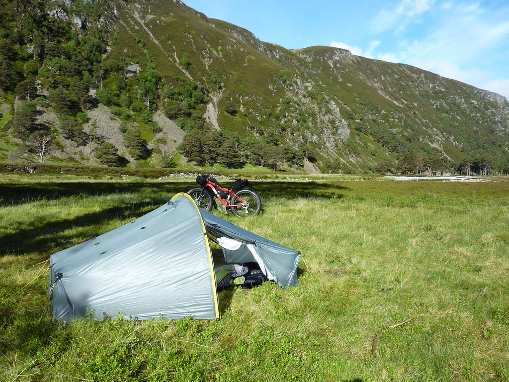
A couple of years ago, I bought myself a new (actually, secondhand) tent. It's a Scarp 1 and has been great for some all-season camping. It's pretty lightweight compared to some of the tents I've used before. It's a bit fussy when pitching and needs a decent flat area to get it just right but it's pretty bomb-proof and very cosy in colder weather.

Scarp 1 in Glen Etive

P1040204
A good pitch in Glen Feshie

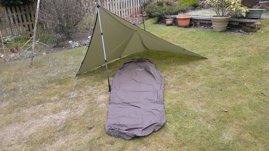
I then decided to try out bivvying. This has worked better than I'd hope. The flexibility of not having to peg anything out makes short overnight stops very easy. Couple that with a small tarp and you get a bit more shelter and somewhere under cover for cooking etc. It's still a bit cramped though and I reckon I prefer a bit more shelter from the elements when the weather isn't too great. 


Untitled
Experimenting in the garden. This "flying V" is my favourite tarp layout
Bivvy bag and tarp above Kinlochleven. Bike being used as a support.

So - I got to thinking about what would be a great combination of the two systems. I imagined a tarp that was a bit bigger, with a pole to give some height. It would have a midge-net built underneath it, linked to a suspended bathtub groundsheet for bug-free sleeping. Ideally, the door would be longitudinal, giving a decent sized porch for gear storage and cooking. It would need to have great ventilation to avoid the build-up of condensation we so often suffer from in our climate and it would, of course, be ultralight. 

Luckily, someone pointed at the Six Moon Designs website and the Lunar Solo tent. Here, it seemed was my design made real.  After my usual bout of swithering, several months later I ordered it from backpackinglight.co.uk and today it arrived.


I've obviously not had a chance to try it out yet. The seams will need to be sealed and I'll want to experiment setting it up a few times to see if there are any snags. However, it seems to match my list of requirements pretty much 100%. I bought a very lightweight carbon pole to go with it but a normal walking pole can be used instead if I'm hiking. It's certainly very lightweight. At just over 700g (including pole and pegs), that's less than my tarp and bivvy bag combined. Internal space is very good - especially as I'm only 5'7" - and there's enough room to get some bags inside with me as well as more space under the porch. The only issue with the latter is that it's quite high off the ground so anything underneath it couldn't be guaranteed to stay dry. It'll also need careful pitching to ensure that any wind is coming over from the rear. 

I reckon there are a few more nights of suitable weather this year before I might need the extra shelter of the Scarp and I'm really looking forward to trying it out.